


 Print
Print Save
Save
 Share
ShareOpen Public Inspections: View at your convenience during daylight hours.
- DO NOT BID unless you have read the Williams & Williams Terms and Conditions of Sale, the Contract for Sale, Property Disclosures, all available due diligence materials, and the Auction Day Notes for each property. BY PLACING YOUR BID, YOU AGREE TO BE BOUND BY THE PROPERTY SPECIFIC CONTRACT FOR SALE, DISCLOSURES, AUCTION DAY NOTES, AND THE WILLIAMS & WILLIAMS TERMS and CONDITIONS OF SALE.
- All properties are sold "AS IS, WHERE IS" with no financing, inspection or other contingencies to sale.
- Escrow. Buyer acknowledges receipt of the Joint Escrow Instructions that modifies the Contract for Sale to provide for a designated Escrow Agent to hold down payment funds. Buyer and Seller agree that the Escrow funds may be held in a trust/escrow account located outside of the state where the Property is located.
- Property Tax Disclosure Summary: Buyer Should Not Rely On The Seller's Current Property Taxes As The Amount Of Property Taxes That The Buyer May Be Obligated To Pay In The Year Subsequent To The Purchase. A Change Of Ownership Or Property Improvements Triggers Reassessments Of The Property That Could Result In Higher Property Taxes. If You Have Any Questions Concerning Valuation, Contact Property Appraiser's Office For Information.
- Square Footage/Acreage Disclosure. The source of the square footage or acreage represented for the property is from public record. Buyer understands and acknowledges that square footage or acreage measurements of a property can vary from a few feet to several hundred feet regardless of source (County Assessor's records, appraisal or appraisal measurement report, survey, etc.). Buyer shall be solely responsible for satisfying that the size and/or square footage or acreage of the property is acceptable to the Buyer.
- Personal Property Not Included. Only title to the real estate is being conveyed. Personal property may be present, but is not included in the auction. Removal of personal property remaining on site at the time of closing is the responsibility of the Buyer.
- Zone, Code, and Use Disclosure. Buyer acknowledges that the Property shall be purchased "AS-IS, WHEREIS, WITH ALL FAULTS." The Property may be subject to city, village, and/or county code or zoning violations, and Buyer accepts the property subject to any such violations. Buyer agrees to conduct an independent search of all property records in the city, county, and/or village prior to bidding and has bid accordingly. Buyer shall be responsible for any and all required remediation of the property, if any. Buyer shall not rely on any information provided by the Seller or Williams & Williams regarding the status of any code or zoning violations, and shall base its decisions on its independent inspection. Buyer also acknowledges that the property may be subject to city, village, and/or county occupancy regulations and requirements which may impact the current and/or future use of the properties. Buyer acknowledges that the seller and Williams & Williams make no warranties of any nature, express or implied, as to the permitted uses of the property, and any prohibition of buyer's intended use of the property shall not be a grounds for terminating the contract.
- Pictures may not reflect specific parcel, entire parcel, or current conditions of any structures that are present.
- Transfer Compliance Disclosure. Buyer understands and acknowledges property may be subject to city/county requirements for transfer/transfer tax. Buyer is responsible for all costs related thereto including any city/county transfer tax or required inspections for dwellings and improvements.
- State Deed Tax or Stamps Disclosure. Buyer understands and acknowledges property may be subject to city/county requirements for State Deed Tax or Stamps. Buyer is responsible for all costs related thereto.
- Title Commitment Disclosure. Buyer understands and acknowledges that at or before closing the buyer, AT BUYER’S SOLE EXPENSE, shall obtain a commitment (the “Title Commitment”) from an Escrow Agent to issue an American Land Title Association owner’s Title Insurance Policy.
- Preclusions to Title Disclosure. Buyer understands and acknowledges that in no event shall Seller be obligated to cure any objection or Preclusion to Title.
- Deed Restriction Disclosure. Buyer understands that Seller will convey a warranty deed to the Property that includes use restrictions. Buyer acknowledges receipt of deed restriction document titled ‘Declaration of Restrictions’ and agrees to accept the conveyance document that includes the terms, conditions and restrictions set forth therein.
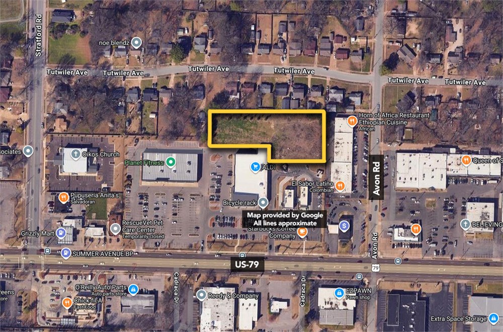
The Land referred to herein below in situated in the County of Shelby, State of Tennessee, and described as follows: Parcel 1: Tract 1: Situated in Shelby County, Tennessee, and within the corporate limits of the City of Memphis, Tennessee, and being part of Lot 13, AVONDALE LAND COMPANY SUBDIVISION, and being more particularly described as follows: Beginning at the point of intersection of the North line of Summer Avenue, as widened, and at its
intersection with the East line of Lot 9, LOUIS MILLER SUBDIVISION, as shown on the plat of record in Plat Book 18, Page 34, in the Shelby County Register's Office, said Point of Beginning being the
Southeast corner of said Lot 9; running thence in a Northwardly direction along the East line of said Lot 9 and along a prolongation thereof a distance of 405.75 feet, more or less, to a point in the South line of Section A, STRATFORD TERRACE SUBDIVISION, as per plat of recond in Plat Book 17, Page 1, in said Register's Office; running thence in an Eastwardly direction along the South line of said Section A of STRATFORD TERRACE SUBDIVISION and along a prolongation thereof a distance of 400 feet to a point; running thence Southwardly and parallel to the East line of Lot 9 of LOUIS MILLER SUBDIVISION, a
distance of 406.45 feet to a point in the North line of Summer Avenue; thence Westwardly and along the North line of Summer Avenue (as widened) a distance of 400 feet to the Point of Beginning. Tract II: Situated in Shelby County, Tennessee, and within the corporate limits of the City of Memphis, Tennessee, and being part of Lot 13, AVONDALE LAND COMPANY SUBDIVISION, and being more particularly described as follows;Beginning at a point in the North line of Summer Avenue, as widened, said point being the Southeast
corner of a part of Lot 13 of AVONDALE LAND COMPANY'S SUBDIVISION conveyed to The Loreco Co. by deed of record in Book 4007, Page 363; thence Northwardly and along the East line of said Loreco Co.'s property, a distance of 406.45 feet to the Northeast corner thereof; thence Eastwardly and along a
prolongation of The Loreco Co.'s North line a distance of 50 feet, more or less, to a point 50 feet East of the East line of The Loreco Co.'s property; thence Southwardly and parallel to the East line of said Loreco Co.'s property, and 50 feet distant therefrom a distance of 406.45 feet, more or less, to a point in the North line of Summer Avenue; thence Westwardly and along the North line of Summer Avenue, 50 feet, more or less, to the Point of Beginning.
Parcel 2: Situated in Shelby County, Tennessee, and within the corporate limits of the City of Memphis, Tennesse, and being part of Lots 12 and 13, AVONDALE LAND COMPANY's Subdivlsion, being more particularly described as follows: Beginning at a point in the North line of Summer Avenue (92 feet wide) 160 feet West of the West line ofAvon Street (40 feet wide) being the Southwest corner of property described in Deed of Trust of record in the Register's Office of Shelby County, Tennessee, in Book 4544, Page 115; thence North and parallel to the West line of Avon Street, passing an iron pin at the Northwest corner of property described in Book 4544, Page 115, at a distance of 200 feet and continuing Northwardly and parallel to the West line of
Avon Street, a distance in all of 507.30 feet to a point in the South line of Section ''B", STRATFORD TERRACE SUBDIVISION, as shown on the plat of record in the Register's Office of Shelby County,
Tennessee, in Plat Book 17, Page 13; thence Westwardly and along said South line and along a
prolongation thereof a distance of 384.69 feet, more or less, to a point 10 feet West of the Southwest
corner of Lot 19 of said subdivision; thence North and parallel to and 10 feet West of the West line of
said Lot 19, a distance of 12 feet to a point in the South line of Tutwiler Avenue; thence Westwardly and along the South line of Tutwiler Avenue a distance of 50 feet to a point in the East line of Lot 11 of
Section "A", STRATFORD TERRACE SUBDIVISION, as shown on plat of record in the aforesaid Register's Office in Plat Book 17, Page 1; thence South and along the East line of said Lot 11, a distance of 225 feet to a point in the North line of property conveyed to Loreco Company by deed of record in the aforesaid Register's Office in Book 4007, Page 363; thence Eastwardly and along the North line of the Loreco Company property a distance of 155.99 feet to an iron pin at the Northeast corner thereof; thence Southwardly and along the East line of the Loreco Company property a distance of 406.64 feet to a point in the North line of Summer Avenue (92 feet wide); thence Eastwardly and along the North line of
Summer Avenue, a distance of 276.40 feet to the Point of Beginning. LESS AND EXCEPT part of Lot 12, AVONDALE LAND COMPANY SUBDIVISION, being more particularly described as follows: Beginning at a point in the South line of Tutwiler Avenue at the Northeast corner of Lot 11, Section A, STRATFORD TERRACE SUBDIVISION, as shown on the plat of record in Plat Book 17, Page 1, in the Register's Office of Shelby County, Tennessee; thence Eastwardly along the South line of Tutwiler Avenue, a distance of 50 feet to a point, said point being 10 feet Westwardly from the Northwest corner of Lot 19, Section B, STRAFFORD TERRACE SUBDIVISION, as shown on the plat of record in Plat Book 17, Page 13, in said Register's Office; thence Southwardly along a line parallel with the East line of Lot 11 and the West line of Lot 19, 125 feet to a point; thence Westwardly parallel with the South line of Tutwiler Avenue, 50 feet to a point in the East line of Lot 1; thence Northwardly along said East line 125 feet to the Point of Beginning. Being the same property conveyed to Aldi Inc., a Tennessee corporation, by Warranty Deed from Summer Avenue Partnership, a Tennessee general partnerhip, of record in Instrument No. 18074033, in the Register’s Office of Shelby County, Tennessee.
- "As-Is, Where-is", no contingencies to sale
- Close within 30 days of seller acceptance, unless otherwise disclosed below
- 5% Buyer's Premium ($7500 minimum)
- 10% Down Payment ($5000 minimum)
- Technology Fee: $299
- View full Terms of Sale
To learn more about auction, visit Help Center or our Frequently Asked Questions.
You can also speak with Customer Service during business hours, call 866.921.2135 or email us.