

 Print
Print Save
Save
 Share
Share
Open Public Inspections: View at your convenience during daylight hours.
- Please review the Addendum to Sale Contract prior to Bidding. It shall be Buyer’s responsibility, prior to expiration of the Subdivision Period and subject to Seller’s approval hereunder, to subdivide the Overall Property such that the Property is a separate legal lot (the “Subdivision”).
- DO NOT BID unless you have read the Williams & Williams Terms and Conditions of Sale, the Contract for Sale, Property Disclosures, all available due diligence materials, and the Auction Day Notes for each property. BY PLACING YOUR BID, YOU AGREE TO BE BOUND BY THE PROPERTY SPECIFIC CONTRACT FOR SALE, DISCLOSURES, AUCTION DAY NOTES, AND THE WILLIAMS & WILLIAMS TERMS and CONDITIONS OF SALE.
- All properties are sold "AS IS, WHERE IS" with no financing, inspection or other contingencies to sale.
- Escrow. Buyer acknowledges receipt of the Joint Escrow Instructions that modifies the Contract for Sale to provide for a designated Escrow Agent to hold down payment funds. Buyer and Seller agree that the Escrow funds may be held in a trust/escrow account located outside of the state where the Property is located.
- Property Tax Disclosure Summary: Buyer Should Not Rely On The Seller's Current Property Taxes As The Amount Of Property Taxes That The Buyer May Be Obligated To Pay In The Year Subsequent To The Purchase. A Change Of Ownership Or Property Improvements Triggers Reassessments Of The Property That Could Result In Higher Property Taxes. If You Have Any Questions Concerning Valuation, Contact Property Appraiser's Office For Information.
- Square Footage/Acreage Disclosure. The source of the square footage or acreage represented for the property is from public record. Buyer understands and acknowledges that square footage or acreage measurements of a property can vary from a few feet to several hundred feet regardless of source (County Assessor's records, appraisal or appraisal measurement report, survey, etc.). Buyer shall be solely responsible for satisfying that the size and/or square footage or acreage of the property is acceptable to the Buyer.
- Personal Property Not Included. Only title to the real estate is being conveyed. Personal property may be present, but is not included in the auction. Removal of personal property remaining on site at the time of closing is the responsibility of the Buyer.
- Zone, Code, and Use Disclosure. Buyer acknowledges that the Property shall be purchased "AS-IS, WHEREIS, WITH ALL FAULTS." The Property may be subject to city, village, and/or county code or zoning violations, and Buyer accepts the property subject to any such violations. Buyer agrees to conduct an independent search of all property records in the city, county, and/or village prior to bidding and has bid accordingly. Buyer shall be responsible for any and all required remediation of the property, if any. Buyer shall not rely on any information provided by the Seller or Williams & Williams regarding the status of any code or zoning violations, and shall base its decisions on its independent inspection. Buyer also acknowledges that the property may be subject to city, village, and/or county occupancy regulations and requirements which may impact the current and/or future use of the properties. Buyer acknowledges that the seller and Williams & Williams make no warranties of any nature, express or implied, as to the permitted uses of the property, and any prohibition of buyer's intended use of the property shall not be a grounds for terminating the contract.
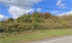
- Pictures may not reflect specific parcel, entire parcel, or current conditions of any structures that are present.
- Transfer Compliance Disclosure. Buyer understands and acknowledges property may be subject to city/county requirements for transfer/transfer tax. Buyer is responsible for all costs related thereto including any city/county transfer tax or required inspections for dwellings and improvements.
- State Deed Tax or Stamps Disclosure. Buyer understands and acknowledges property may be subject to city/county requirements for State Deed Tax or Stamps. Buyer is responsible for all costs related thereto.
- Title Commitment Disclosure. Buyer understands and acknowledges that at or before closing the buyer, AT BUYER’S SOLE EXPENSE, shall obtain a commitment (the “Title Commitment”) from an Escrow Agent to issue an American Land Title Association owner’s Title Insurance Policy.
- Preclusions to Title Disclosure. Buyer understands and acknowledges that in no event shall Seller be obligated to cure any objection or Preclusion to Title.
- Deed Restriction Disclosure. Buyer understands that Seller will convey a warranty deed to the Property that includes use restrictions. Buyer acknowledges receipt of deed restriction document titled ‘Declaration of Restrictions’ and agrees to accept the conveyance document that includes the terms, conditions and restrictions set forth therein.
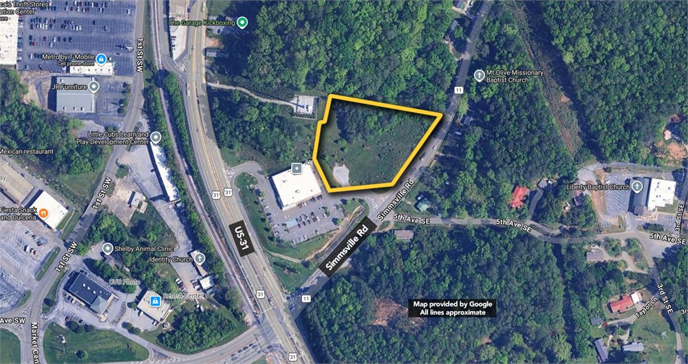
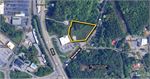
A PARCEL OF LAND SITUATED IN THE NORTHEAST ONE-QUARTER OF SECTION 2, TOWNSHIP 21 SOUTH, RANGE 3 WEST, SHELBY COUNTY, ALABAMA BEING ALL OF LOT 14 THROUGH 25 OF BUCK CREEK COTTON MILL SUBDIVISION AS RECORDED IN MAP BOOK 3, PAGE 9 IN THE OFFICE OF THE JUDGE OF PROBATE OF SHELBY COUNTY, ALABAMA BEING MORE PARTICULARLY DESCRIBED AS FOLLOWS: BEGINNING AT A FOUND SAIN CAPPED IRON MARKING THE SOUTHEAST CORNER OF LOT 11, BLOCK 2 BUCK CREEK COTTON MILL SUBDIVISION AS RECORDED IN MAP BOOK 3, PAGE 9 IN THE OFFICE OF THE JUDGE OF PROBATE OF SHELBY COUNTY, ALABAMA LYING ON THE WESTERLY RIGHT OF WAY OF SIMMSVILLE ROAD (RIGHT OF WAY VARIES) SAID POINT ALSO LYING ON A CURVE TURNING TO THE RIGHT WITH A RADIUS OF 830.74 FEET, WITH A DELTA ANGLE OF 43 DEGREES 51 MINUTES 12 SECONDS, WITH A CHORD BEARING OF SOUTH 42 DEGREES 35 MINUTES 55 SECONDS WEST, AND WITH A CHORD LENGTH OF 620.43 FEET; THENCE RUN ALONG THE ARC OF SAID CURVE AND ALONG SAID WESTERLY RIGHT OF WAY FOR A DISTANCE OF 635.83 FEET TO A SET 5/8 INCH CAPPED REBAR STAMPED GSA CA-560LS; THENCE RUN SOUTH 65 DEGREES 57 MINUTES 18 SECONDS WEST ALONG SAID WESTERLY RIGHT OF WAY FOR A DISTANCE OF 64.20 FEET TO A SET 5/8 INCH CAPPED REBAR STAMPED GSA CA-560LS; THENCE RUN NORTH 86 DEGREES 39 MINUTES 36 SECONDS WEST ALONG SAID WESTERLY RIGHT OF WAY FOR A DISTANCE OF 91.76 FEET TO A SET 5/8 INCH CAPPED REBAR STAMPED GSA CA-560LS LYING ON THE EASTERLY RIGHT OF WAY OF U.S. HIGHWAY 31 (RIGHT OF WAY VARIES); THENCE LEAVING SAID WESTERLY RIGHT OF WAY OF SIMMSVILLE ROAD RUN IN A NORTHERLY DIRECTION ALONG A SPIRAL CURVE TURNING TO THE RIGHT AND ALONG SAID EASTERLY RIGHT OF WAY OF U.S. HIGHWAY 31 SAID SPIRAL CURVE HAVING A CHORD BEARING OF NORTH 24 DEGREES 48 MINUTES 11 SECONDS WEST AND A CHORD DISTANCE OF 228.53 FEET TO A SET 5/8 INCH CAPPED REBAR STAMPED GSA CA-560LS LYING ON A CURVE TURNING TO THE RIGHT WITH A RADIUS OF 1332.71 FEET, WITH A DELTA ANGLE OF 07 DEGREES 01 MINUTES 39 SECONDS, WITH A CHORD BEARING OF NORTH 17 DEGREES 45 MINUTES 08 SECONDS WEST, AND WITH A CHORD LENGTH OF 163.36 FEET; THENCE RUN ALONG THE ARC OF SAID CURVE AND ALONG SAID EASTERLY RIGHT OF WAY OF U.S. HIGHWAY 31 FOR A DISTANCE OF 163.46 FEET TO A SET 5/8 INCH CAPPED REBAR STAMPED GSA CA-560LS; THENCE RUN SOUTH 75 DEGREES 50 MINUTES 04 SECONDS WEST ALONG SAID EASTERLY RIGHT OF WAY OF U.S. HIGHWAY 31 FOR A DISTANCE OF 50.17 FEET TO A FOUND CONCRETE MONUMENT LYING ON A CURVE TURNING TO THE RIGHT WITH A RADIUS OF 1382.69 FEET, WITH A DELTA ANGLE OF 04 DEGREES 57 MINUTES 48 SECONDS, WITH A CHORD BEARING OF NORTH 11 DEGREES 47 MINUTES 18 SECONDS WEST, AND WITH A CHORD LENGTH OF 119.74 FEET; THENCE RUN ALONG THE ARC OF SAID CURVE AND ALONG SAID EASTERLY RIGHT OF WAY OF U.S. HIGHWAY 31 FOR A DISTANCE OF 119.78 FEET TO A FOUND SAIN CAPPED IRON MARKING THE SOUTHWEST CORNER OF LOT 13, BLOCK 2, BUCK CREEK COTTON MILL SUBDIVISION; THENCE LEAVING SAID EASTERLY RIGHT OF WAY OF U.S. HIGHWAY 31 RUN SOUTH 83 DEGREES 24 MINUTES 58 SECONDS EAST ALONG THE SOUTH LINE OF SAID LOT 13 FOR A DISTANCE OF 382.76 FEET TO A SET 5/8 INCH CAPPED REBAR STAMPED GSA CA-560LS; THENCE LEAVING THE SAID SOUTH LINE RUN NORTH 06 DEGREES 36 MINUTES 44 SECONDS EAST FOR A DISTANCE OF 100.00 FEET TO A SET 5/8 INCH CAPPED REBAR STAMPED GSA CA-560LS LYING ON THE SOUTH LINE OF SAID LOT 11; THENCE RUN SOUTH 83 DEGREES 24 MINUTES 32 SECONDS EAST ALONG SAID SOUTH LINE FOR A DISTANCE OF 399.85 FEET TO THE POINT OF BEGINNING. SAID PARCEL CONTAINS 243,323 SQUARE FEET OR 5.59 ACRES MORE OR LESS. LESS AND EXCEPT THAT PORTION OF THE ABOVE DESCRIBED PROPERTY DESCRIBED IN THAT CERTAIN FEE SIMPLE WARRANTY DEED FROM ALDI, INC. TO SHELBY COUNTY RECORDED IN INSTRUMENT NO. 20140714000211260 IN THE PROBATE OFFICE OF SHELBY COUNTY, ALABAMA AND BEING MORE PARTICULARLY DESCRIBED AS FOLLOWS: A PARCEL OF LAND SITUATED IN THE NORTHEAST ONE-QUARTER OF SECTION 2, TOWNSHIP 21 SOUTH, RANGE 3 WEST, SHELBY COUNTY, ALABAMA BEING A PART OF LOT 14 THROUGH 25 OF BUCK CREEK COTTON MILL SUBDIVISION AS RECORDED IN MAP BOOK 3, PAGE 9 IN THE OFFICE OF THE JUDGE OF PROBATE OF SHELBY COUNTY, ALABAMA BEING MORE PARTICULARLY DESCRIBED AS FOLLOWS:
COMMENCING AT A FOUND SAIN CAPPED IRON MARKING THE SOUTHEAST CORNER OF LOT 11, BLOCK 2 BUCK CREEK COTTON MILL SUBDIVISION AS RECORDED IN MAP BOOK 3, PAGE 9 IN THE OFFICE OF THE JUDGE OF PROBATE OF SHELBY COUNTY, ALABAMA LYING ON THE WESTERLY RIGHT OF WAY OF SIMMSVILLE ROAD (RIGHT OF WAY VARIES) SAID POINT ALSO LYING ON A CURVE TURNING TO THE RIGHT WITH A RADIUS OF 830.74 FEET, A CENTRAL ANGLE OF 07 DEGREES 35 MINUTES 11 SECONDS, A CHORD BEARING OF SOUTH 24 DEGREES 27 MINUTES 54 SECONDS WEST, AND A CHORD DISTANCE 109.91 FEET; THENCE RUN ALONG THE ARC OF SAID CURVE AND ALONG SAID WESTERLY RIGHT OF WAY FOR A DISTANCE OF 109.99 FEET TO A SET 5/8 INCH CAPPED REBAR STAMPED GSA CA-560LS BEING THE POINT OF BEGINNING OF THE PARCEL HEREIN DESCRIBED SAID POINT LYING ON A CURVE TURNING TO THE RIGHT WITH A RADIUS OF 830.74 FEET, A CENTRAL ANGLE OF 21 DEGREES 14 MINUTES 24 SECONDS, A CHORD BEARING OF SOUTH 38 DEGREES 52 MINUTES 42 SECONDS WEST, AND A CHORD DISTANCE OF 306.20 FEET; THENCE RUN ALONG THE ARC OF SAID CURVE AND ALONG SAID WESTERLY RIGHT OF WAY FOR A DISTANCE OF 307.96 FEET TO A SET 5/8 INCH CAPPED REBAR STAMPED GSA CA-560LS LYING ON A NON-TANGENT CURVE TURNING TO THE LEFT WITH A RADIUS OF 456.15 FEET, A CENTRAL ANGLE OF 10 DEGREES 21 MINUTES 03 SECONDS, A CHORD BEARING OF NORTH 42 DEGREES 36 MINUTES 40 SECONDS EAST, AND A CHORD LENGTH OF 82.30 FEET; THENCE LEAVING SAID WESTERLY RIGHT OF WAY RUN ALONG THE ARC OF SAID CURVE FOR A DISTANCE OF 82.41 FEET TO A SET 5/8 INCH CAPPED REBAR STAMPED GSA CA-560LS; THENCE RUN NORTH 37 DEGREES 30 MINUTES 31 SECONDS EAST FOR A DISTANCE OF 224.15 FEET TO THE POINT OF BEGINNING. SAID PARCEL CONTAINS 1,987 SQUARE FEET OR 0.05 ACRES MORE OR LESS.
- "As-Is, Where-is", no contingencies to sale
- Close within 30 days of seller acceptance, unless otherwise disclosed below
- 5% Buyer's Premium ($5000 minimum)
- 10% Down Payment ($5000 minimum)
- Technology Fee: $299
- View full Terms of Sale
To learn more about auction, visit Help Center or our Frequently Asked Questions.
You can also speak with Customer Service during business hours, call 866.921.2135 or email us.