


 Print
Print Save
Save
 Share
Share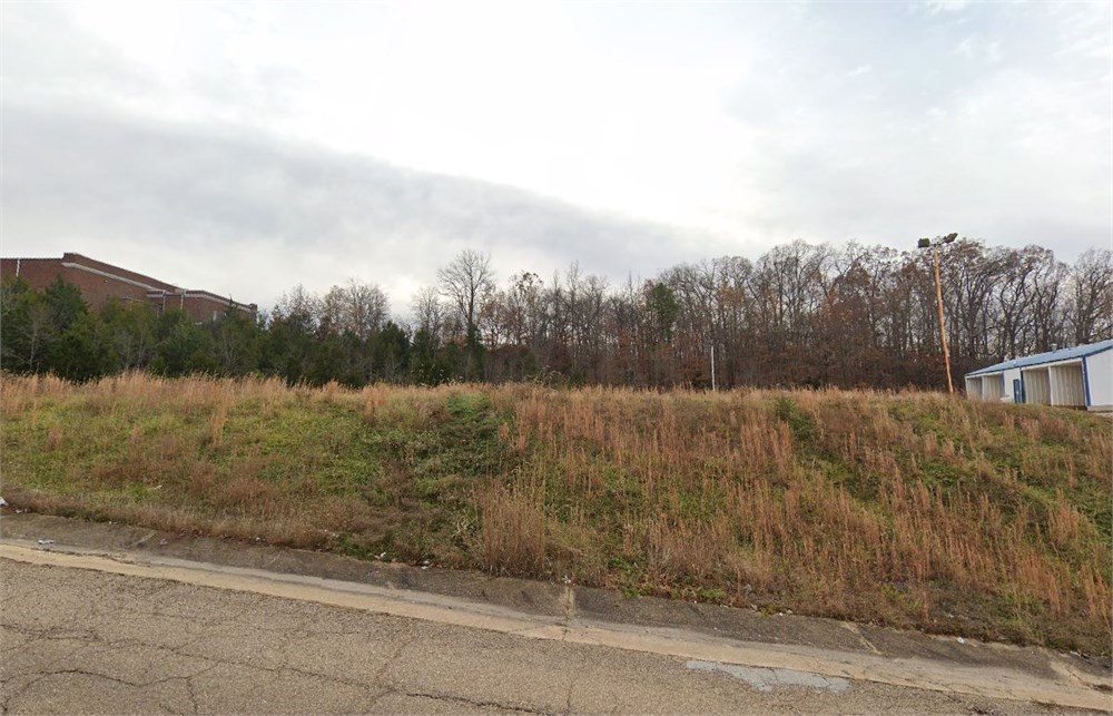
Open Public Inspections: View at your convenience during daylight hours.
- DO NOT BID unless you have read the Williams & Williams Terms & Conditions of Sale, the Contract for Sale, Property Disclosures, all available due diligence materials, and the Auction Day Notes for each property. BY PLACING YOUR BID, YOU AGREE TO BE BOUND BY THE PROPERTY SPECIFIC CONTRACT FOR SALE, DISCLOSURES, AUCTION DAY NOTES, AND THE WILLIAMS & WILLIAMS TERMS & CONDITIONS OF SALE.
- All properties are sold "AS IS, WHERE IS" with no financing, inspection or other contingencies to sale.
- Escrow. Buyer acknowledges receipt of the Joint Escrow Instructions that modifies the Contract for Sale to provide for a designated Escrow Agent to hold down payment funds. Buyer and Seller agree that the Escrow funds may be held in a trust/escrow account located outside of the state where the Property is located.
- Property Tax Disclosure Summary: Buyer Should Not Rely On The Seller's Current Property Taxes As The Amount Of Property Taxes That The Buyer May Be Obligated To Pay In The Year Subsequent To The Purchase. A Change Of Ownership Or Property Improvements Triggers Reassessments Of The Property That Could Result In Higher Property Taxes. If You Have Any Questions Concerning Valuation, Contact Property Appraiser's Office For Information.
- Square Footage/Acreage Disclosure. The source of the square footage or acreage represented for the property is from public record. Buyer understands and acknowledges that square footage or acreage measurements of a property can vary from a few feet to several hundred feet regardless of source (County Assessor's records, appraisal or appraisal measurement report, survey, etc.). Buyer shall be solely responsible for satisfying that the size and/or square footage or acreage of the property is acceptable to the Buyer.
- Personal Property Not Included. Only title to the real estate is being conveyed. Personal property may be present, but is not included in the auction. Removal of personal property remaining on site at the time of closing is the responsibility of the Buyer.
- Zone, Code, and Use Disclosure. Buyer acknowledges that the Property shall be purchased "AS-IS, WHEREIS, WITH ALL FAULTS." The Property may be subject to city, village, and/or county code or zoning violations, and Buyer accepts the property subject to any such violations. Buyer agrees to conduct an independent search of all property records in the city, county, and/or village prior to bidding and has bid accordingly. Buyer shall be responsible for any and all required remediation of the property, if any. Buyer shall not rely on any information provided by the Seller or Williams & Williams regarding the status of any code or zoning violations, and shall base its decisions on its independent inspection. Buyer also acknowledges that the property may be subject to city, village, and/or county occupancy regulations and requirements which may impact the current and/or future use of the properties. Buyer acknowledges that the seller and Williams & Williams make no warranties of any nature, express or implied, as to the permitted uses of the property, and any prohibition of buyer's intended use of the property shall not be a grounds for terminating the contract.
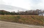
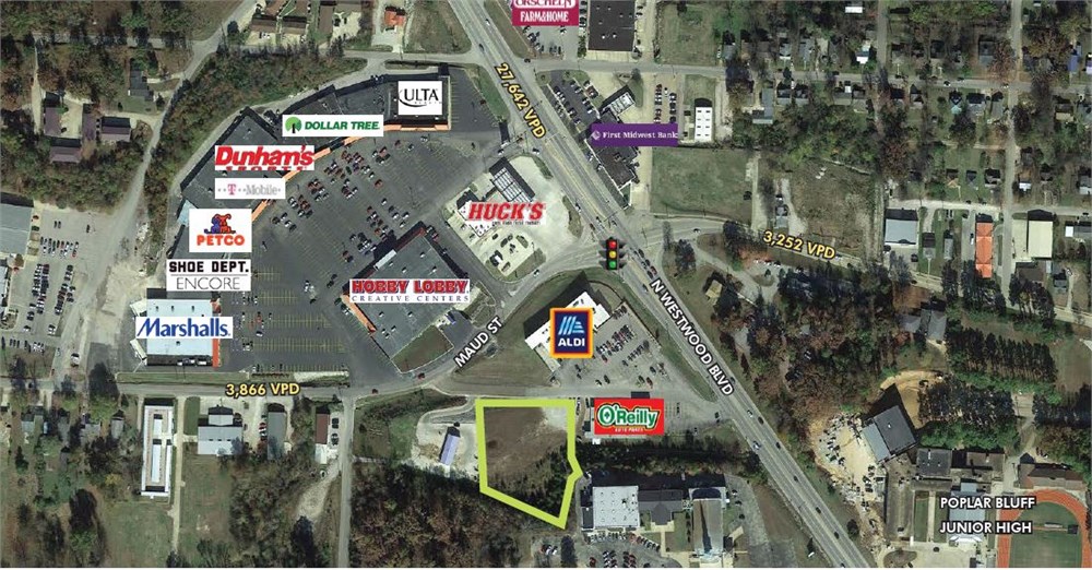
- Pictures may not reflect specific parcel, entire parcel, or current conditions of any structures that are present.
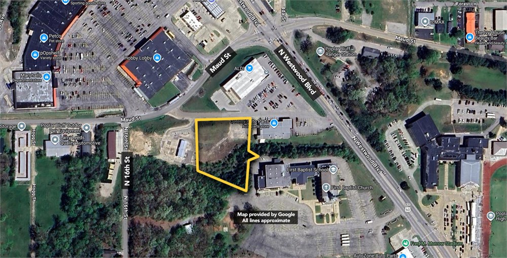
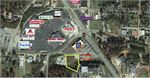
The Land is described as follows: ALL OF THAT CERTAIN PROPERTY KNOWN AS "ALDI CENTER" ACCORDING TO THE PLAT THEREOF RECORDED IN BOOK 8 AT PAGE 457 IN THE OFFICE OF THE RECORDER OF DEEDS IN BUTLER COUNTY, MISSOURI FURTHER DESCRIBED AS FOLLOWS: LOTS 25, 27 AND 28, LEUER'S ADDITION TO THE CITY OF POPLAR BLUFF, BUTLER COUNTY, MISSOURI, AND PART OF MARIE STREET IN LEUER'S ADDITION AS CLOSED AND VACATED BY ORDINANCE NO. 4169, MORE PARTICULARLY DESCRIBED AS FOLLOWS: FROM THE NORTHEAST CORNER OF THE INTERSECTION OF NORTH 16TH STREET AND PERRY AVENUE, BEING ALSO THE SOUTHWEST CORNER OF LOT 28, SAID LEUER'S ADDITION, RUN NORTH 02 DEGREES 28 MINUTES 08 SECONDS EAST AND ALONG THE EAST RIGHT-OF-WAY OF NORTH 16TH STREET AND THE WEST LINE OF SAID LOT 28, 152.80 FEET TO A POINT ON A CURVE CONCAVE TO THE NORTHWEST WHOSE RADIUS IS 468.46 FEET AND THE SOUTHERLY RIGHT-OF-WAY LINE OF WEST MAUDE STREET; THENCE ALONG THE ARC OF SAID CURVE AND RIGHT-OF-WAY LINE (CHORD BEARING AND DISTANCE NORTH 63 DEGREES 12 MINUTES 30 SECONDS EAST 397.60 FEET) AND WESTERLY LINE OF LOTS 28 AND 27 TO THE P.T. OF SAID CURVE; THENCE CONTINUE ALONG SAID RIGHT-OF-WAY LINE AND WESTERLY OR NORTHERLY LINE OF LOT 27, NORTH 39 DEGREES 12 MINUTES EAST 156.70 FEET; THENCE NORTH 47 DEGREES 29 MINUTES 28 SECONDS EAST 20.80 FEET TO A CONCRETE MONUMENT; THENCE CONTINUE ALONG
SAID RIGHT-OF-WAY LINE AND NORTHERLY LINE OF LOT 27, NORTH 70 DEGREES 43 MINUTES 20 SECONDS EAST 86.70 FEET TO A CONCRETE MONUMENT; THENCE CONTINUE ALONG SAID RIGHT-OF-WAY LINE AND NORTHERLY LINE OF LOT 27, NORTH 85 DEGREES 36 MINUTES 10 SECONDS EAST
61.10 FEET TO A CONCRETE MONUMENT ON THE WESTERLY RIGHT-OF-WAY LINE OF U. S. HIGHWAY 60-67, THENCE ALONG SAID RIGHT-OF-WAY LINE AND NORTHERLY LINE OF LOT 27, SOUTH 60 DEGREES 30 MINUTES 54 SECONDS EAST 54.30 FEET TO A CONCRETE MONUMENT; THENCE
CONTINUE ALONG SAID RIGHT-OF-WAY LINE AND NORTHERLY LINE OF LOT 27, SOUTH 41 DEGREES
19 MINUTES AND 30 SECONDS EAST 160.20 FEET TO A CONCRETE MONUMENT; THENCE CONTINUE ALONG SAID RIGHT-OF-WAY LINE AND NORTHERLY LINE OF LOT 27 SOUTH 45 DEGREES 31 MINUTES 50 SECONDS EAST 70.50 FEET TO A CONCRETE MONUMENT; THENCE CONTINUE ALONG SAID RIGHT-OF-WAY LINE AND NORTHERLY LINE OF LOT 27 AND THE EASTERLY LINE OF LOT 25, SOUTH 37 DEGREES 33 MINUTES EAST 230.00 FEET TO AN IRON PIN; THENCE CONTINUE ALONG SAID RIGHT-
OF-WAY LINE AND EASTERLY LINE OF LOT 25, SOUTH 37 DEGREES 23 MINUTES 54 SECONDS EAST 130.30 FEET TO THE SOUTHEAST CORNER OF LOT 25 AND THE NORTHEAST CORNER OF LOT 17; THENCE SOUTH 86 DEGREES 04 MINUTES 42 SECONDS WEST AND ALONG THE SOUTH LINE OF LOT 25 AND SAID LINE PROJECTED WESTERLY AND THE NORTH LINE OF LOTS 17 THROUGH 24 INCLUSIVE 454.99 FEET TO THE CENTERLINE OF VACATED MARIE STREET; THENCE SOUTH 02 DEGREES 10 MINUTES 38 SECONDS WEST AND ALONG THE VACATED CENTERLINE OF MARIE STREET 149.50 FEET TO THE SOUTHEAST CORNER OF LOT 28 AND THE NORTH LINE OF PERRY AVENUE; THENCE NORTH 74 DEGREES 25 MINUTES 22 SECONDS WEST AND ALONG THE NORTH LINE OF PERRY AVENUE AND THE SOUTH LINE OF LOT 28, 603.83 FEET TO THE POINT OF BEGINNING. LESS AND EXCEPT: ALL OF LOT 2 AND THAT PART OF LOT 5 OF ALDI CENTER SUBDIVISION, THE PLAT OF WHICH IS FILED IN BOOK 8, PAGE 457 IN THE BUTLER COUNTY RECORDER'S OFFICE, AND BEING A PART OF THE NORTHEAST QUARTER OF SECTION 4, TOWNSHIP 24 NORTH, RANGE 6 EAST OF THE FIFTH PRINCIPAL MERIDIAN, CITY OF POPLAR BLUFF, BUTLER COUNTY, MISSOURI, DESCRIBED AS FOLLOWS:
FROM A ½ INCH REBAR MARKING THE SOUTHEAST CORNER OF SAID LOT 2 AND THE POINT OF BEGINNING, MEASURE SOUTH 86 DEGREES15 MINUTES WEST ALONG AND WITH THE SOUTH LINE OF LOTS 2 AND 5 A DISTANCE OF 455.3 FEET TO A ½ INCH REBAR ON THE EASTERLY LINE OF LOT 3; THENCE NORTH 48 DEGREES 36 MINUTES WEST ALONG AND WITH THE LINE BETWEEN LOTS 3 AND 5 A DISTANCE OF 51.8 FEET TO A ½ INCH REBAR, THENCE, NORTH 02 DEGREES 16 MINUTES WEST ALONG AND WITH THE LINE BETWEEN LOTS 3 AND 5 AND A NORTHWARD PROJECTION THEREOF A DISTANCE OF 177.7 FEET TO A MAGNETIC NAIL IN ASPHALT; THENCE, NORTH 88 DEGREES 32 MINUTES EAST A DISTANCE OF 315.4 FEET TO A MAGNETIC NAIL IN ASPHALT, THENCE, SOUTH 37 DEGREES 33 MINUTES EAST A DISTANCE OF 81.5 FEET TO A MAGNETIC NAIL IN ASPHALT THENCE, NORTH 52 DEGREES 27 MINUTES EAST A DISTANCE OF 30.7 FEET TO THE WESTERLY RIGHT OF WAY LINE OF BUSINESS U.S. HIGHWAY "67"; THENCE SOUTH 37 DEGREES 33 MINUTES EAST ALONG AND WITH SAID RIGHT OF WAY LINE A DISTANCE OF 181.9 FEET TO THE POINT OF BEGINNING. SUBJECT TO EASEMENTS AND RIGHTS OF WAY. ALSO LESS AND EXCEPT:
LOT 7 OF ALDI CENTER ACCORDING TO THE PLAT THEREOF RECORDED IN DRAWER 8 AT PAGE 457 IN THE OFFICE OF THE RECORDER OF DEEDS IN BUTLER COUNTY, MISSOURI. AND ALSO LESS AND EXCEPT:
LOT 4 OF ALDI CENTER AS SHOWN BY THE PLAT OF SAME ON FILE IN THE OFFICE OF THE RECORDER OF DEEDS IN AND FOR BUTLER COUNTY, MISSOURI.
- "As-Is, Where-is", no contingencies to sale
- Close within 30 days of seller acceptance
- 5% Buyer's Premium ($7500 minimum)
- 10% Down Payment ($5000 minimum)
- Technology Fee: $299
- View full Terms of Sale
To learn more about auction, visit Help Center or our Frequently Asked Questions.
You can also speak with Customer Service during business hours, call 866.921.2135 or email us.