


 Print
Print Save
Save
 Share
Share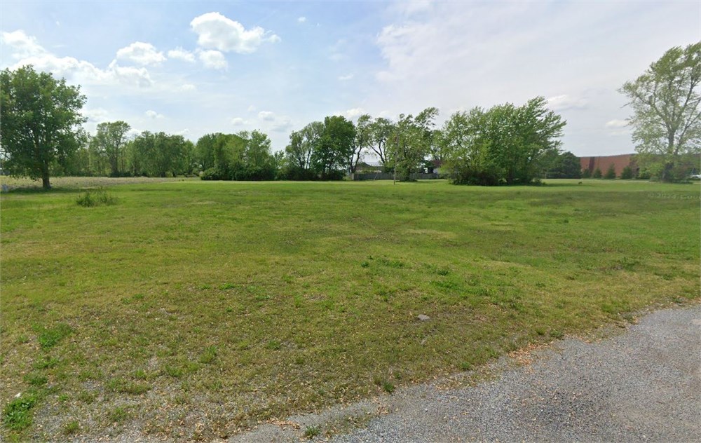
Open Public Inspections: View at your convenience during daylight hours.
- DO NOT BID unless you have read the Williams & Williams Terms & Conditions of Sale, the Contract for Sale, Property Disclosures, all available due diligence materials, and the Auction Day Notes for each property. BY PLACING YOUR BID, YOU AGREE TO BE BOUND BY THE PROPERTY SPECIFIC CONTRACT FOR SALE, DISCLOSURES, AUCTION DAY NOTES, AND THE WILLIAMS & WILLIAMS TERMS & CONDITIONS OF SALE.
- All properties are sold "AS IS, WHERE IS" with no financing, inspection or other contingencies to sale.
- Escrow. Buyer acknowledges receipt of the Joint Escrow Instructions that modifies the Contract for Sale to provide for a designated Escrow Agent to hold down payment funds. Buyer and Seller agree that the Escrow funds may be held in a trust/escrow account located outside of the state where the Property is located.
- Property Tax Disclosure Summary: Buyer Should Not Rely On The Seller's Current Property Taxes As The Amount Of Property Taxes That The Buyer May Be Obligated To Pay In The Year Subsequent To The Purchase. A Change Of Ownership Or Property Improvements Triggers Reassessments Of The Property That Could Result In Higher Property Taxes. If You Have Any Questions Concerning Valuation, Contact Property Appraiser's Office For Information.
- Square Footage/Acreage Disclosure. The source of the square footage or acreage represented for the property is from public record. Buyer understands and acknowledges that square footage or acreage measurements of a property can vary from a few feet to several hundred feet regardless of source (County Assessor's records, appraisal or appraisal measurement report, survey, etc.). Buyer shall be solely responsible for satisfying that the size and/or square footage or acreage of the property is acceptable to the Buyer.
- Personal Property Not Included. Only title to the real estate is being conveyed. Personal property may be present, but is not included in the auction. Removal of personal property remaining on site at the time of closing is the responsibility of the Buyer.
- Zone, Code, and Use Disclosure. Buyer acknowledges that the Property shall be purchased "AS-IS, WHEREIS, WITH ALL FAULTS." The Property may be subject to city, village, and/or county code or zoning violations, and Buyer accepts the property subject to any such violations. Buyer agrees to conduct an independent search of all property records in the city, county, and/or village prior to bidding and has bid accordingly. Buyer shall be responsible for any and all required remediation of the property, if any. Buyer shall not rely on any information provided by the Seller or Williams & Williams regarding the status of any code or zoning violations, and shall base its decisions on its independent inspection. Buyer also acknowledges that the property may be subject to city, village, and/or county occupancy regulations and requirements which may impact the current and/or future use of the properties. Buyer acknowledges that the seller and Williams & Williams make no warranties of any nature, express or implied, as to the permitted uses of the property, and any prohibition of buyer's intended use of the property shall not be a grounds for terminating the contract.
- Pictures may not reflect specific parcel, entire parcel, or current conditions of any structures that are present.
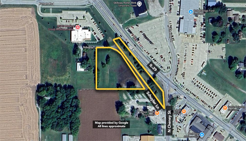
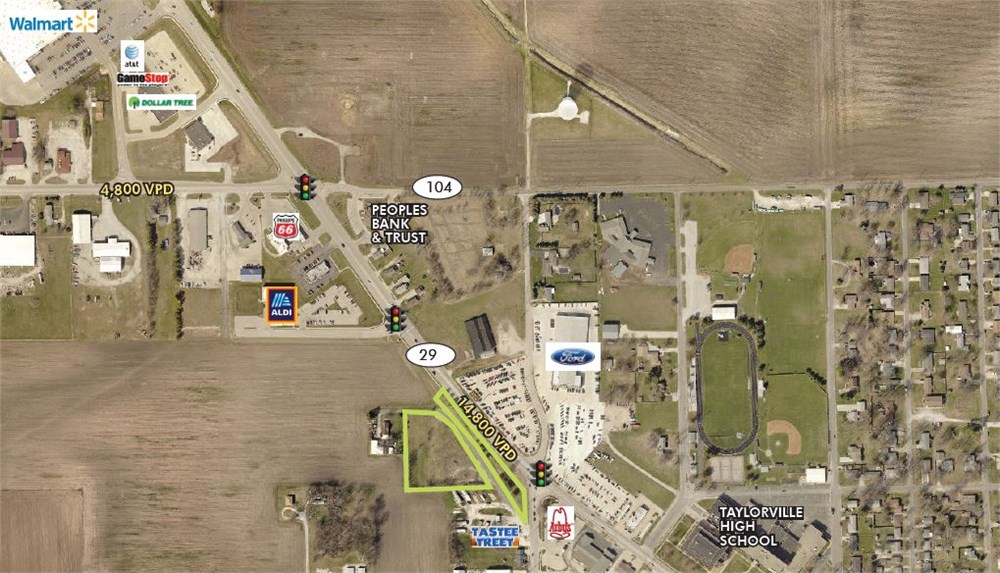
Parcel 1: Part of out Lot 3 of CITY PARK OUT LOTS to Taylorville described as follows: Beginning at the intersection of the South line of the Northeast Quarter of the Northeast Quarter of Section 21, Township 13 North, Range 2 West of the Third Principal Meridian, with the Southwesterly right of way line of the B & O Southwestern Railroad and running thence West along the South line of the said Northeast Quarter of the Northeast Quarter of said Section 21 to a point which is 551.38 feet West of the Southeast corner of said Northeast Quarter of the Northeast Quarter; thence North 160
feet; thence East 90 feet on a line parallel to the South line of the Northeast Quarter of the Northeast Quarter of said Section 21; thence North 150 feet to the South line of a 20 foot public road; thence East to the Southwesterly line of the right of way of the B & O Southwestern Railroad; thence Southeasterly along said right of way line to the true Place of Beginning, according to the plat thereof recorded March 18, 1915 in Plat Book 2 Page 11, except the coal and other minerals underlying the surface of said land and the right to mine and remove the same, in Christian County, Illinois.
AND
Parcel 2: The North 150 feet of the South 310 feet of the West 90 feet of the East 551.38 feet of the Northeast Quarter of the Northeast Quarter of Section 21, being a part of Out Lot 3 of CITY PARK OUT LOTS, a subdivision in the Northeast Quarter of Section 21, Township 13 North, Range 2 West of the Third Principal Meridian, according to the plat recorded March 18, 1915 in Plat Book 2 Page 11, except the coal and other minerals underlying the surface of said land and the right to mine and remove the same, in Christian County, Illinois.
AND
Parcel 3: That part of the Northeast Quarter of Section 21, Township 13 North, Range 2 West of the Third Principal Meridian, described as follows: Commencing at a point on the East line of said Section 21 lying 1391.99 feet South of the Northeast corner of said section; thence North 35° 07' 57" West 72.15 feet to the Point of Beginning; thence North 35° 07' 57" West 396.81 feet; thence around a curve to the right having a radius of 2883.83 feet and a chord that bears North 39° 38' 21" West for a distance of 219.16 feet; thence South 54° 52' 03" West 82.78 feet; thence South 35° 07' 57" East 765.40 feet to a point on the West line of
Cheney Street in the City of Taylorville; thence North 1° 27' 43" West 180.37 feet along the West line of Cheney Street to the Point of Beginning, except the coal and other minerals underlying the surface of said land and the right to mine and remove the same, in Christian County, Illinois.
- "As-Is, Where-is", no contingencies to sale
- Close within 30 days of seller acceptance
- 5% Buyer's Premium ($10000 minimum)
- 10% Down Payment ($5000 minimum)
- Technology Fee: $299
- View full Terms of Sale
To learn more about auction, visit Help Center or our Frequently Asked Questions.
You can also speak with Customer Service during business hours, call 866.921.2135 or email us.