

 Print
Print Save
Save
 Share
Share
Open Public Inspections: View at your convenience during daylight hours.
- Texas law requires that auctioneers notify consumers that consumers may contact the Texas Department of Licensing and Regulation, PO Box 12157, Austin, TX 78711 or by phone at 800-803-9202 for the purpose of making a complaint regarding a Texas auction.
- Texas Law requires all real estate license holders to give the following information about brokerage services to prospective buyers, tenants, sellers and landlords. This information is available in the Documents section of the Property Detail Page on the website.
- DO NOT BID unless you have read the Williams & Williams Terms & Conditions of Sale, the Contract for Sale, Property Disclosures, all available due diligence materials, and the Auction Day Notes for each property. BY PLACING YOUR BID, YOU AGREE TO BE BOUND BY THE PROPERTY SPECIFIC CONTRACT FOR SALE, DISCLOSURES, AUCTION DAY NOTES, AND THE WILLIAMS & WILLIAMS TERMS & CONDITIONS OF SALE.
- All properties are sold "AS IS, WHERE IS" with no financing, inspection or other contingencies to sale.
- Escrow. Buyer acknowledges receipt of the Joint Escrow Instructions that modifies the Contract for Sale to provide for a designated Escrow Agent to hold down payment funds. Buyer and Seller agree that the Escrow funds may be held in a trust/escrow account located outside of the state where the Property is located.
- Property Tax Disclosure Summary: Buyer Should Not Rely On The Seller's Current Property Taxes As The Amount Of Property Taxes That The Buyer May Be Obligated To Pay In The Year Subsequent To The Purchase. A Change Of Ownership Or Property Improvements Triggers Reassessments Of The Property That Could Result In Higher Property Taxes. If You Have Any Questions Concerning Valuation, Contact Property Appraiser's Office For Information.
- Square Footage/Acreage Disclosure. The source of the square footage or acreage represented for the property is from public record. Buyer understands and acknowledges that square footage or acreage measurements of a property can vary from a few feet to several hundred feet regardless of source (County Assessor's records, appraisal or appraisal measurement report, survey, etc.). Buyer shall be solely responsible for satisfying that the size and/or square footage or acreage of the property is acceptable to the Buyer.
- Personal Property Not Included. Only title to the real estate is being conveyed. Personal property may be present, but is not included in the auction. Removal of personal property remaining on site at the time of closing is the responsibility of the Buyer.
- Zone, Code, and Use Disclosure. Buyer acknowledges that the Property shall be purchased "AS-IS, WHEREIS, WITH ALL FAULTS." The Property may be subject to city, village, and/or county code or zoning violations, and Buyer accepts the property subject to any such violations. Buyer agrees to conduct an independent search of all property records in the city, county, and/or village prior to bidding and has bid accordingly. Buyer shall be responsible for any and all required remediation of the property, if any. Buyer shall not rely on any information provided by the Seller or Williams & Williams regarding the status of any code or zoning violations, and shall base its decisions on its independent inspection. Buyer also acknowledges that the property may be subject to city, village, and/or county occupancy regulations and requirements which may impact the current and/or future use of the properties. Buyer acknowledges that the seller and Williams & Williams make no warranties of any nature, express or implied, as to the permitted uses of the property, and any prohibition of buyer's intended use of the property shall not be a grounds for terminating the contract.
- Pictures may not reflect specific parcel, entire parcel, or current conditions of any structures that are present.
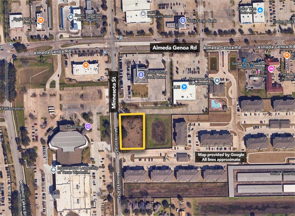
EXHIBIT "A"
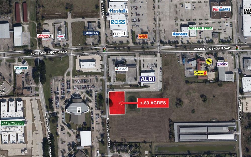
A field note description of a 1.9422 acre (84,601 square feet) tract of land in the J. Robinson Survey, Abstract No. 680, City of Houston, Harris County, Texas; said 1.9422 acre tract being out of Unrestricted Reserve “A”, Block 1, CEASER MOORE SR., ADDITION, according to the map or plat recorded in Film Code No. 573237 of the Harris County Map Records, owned by Houston Postal Credit Union and described as 4.6 acres in Harris County Clerk’s File No. X756541; said tract being more particularly described by metes-and-bounds as follows with the bearings being based on Texas State Plane Coordinate System, South Central Zone (NAD83) per GPS Observations using National Geodetic Survey Continuously Operating Reference Stations: Commencing for reference at a 1/2-inch iron rod found in the South right-of-way line of Almeda-Genoa Road (called 100 feet wide), as recorded in Harris County Clerk’s File No. D911725 for the Northeast corner of said Ceaser Moore Sr., Addition and for a Northwest corner of Unrestricted Reserve “A”, Block 1, Superior Plaza
Almeda, according to the map or plat recorded in Film Code No. 663068 of the Harris County Map Records; Thence, South 02° 35’ 53” East - 350.47 feet with the West line of said Superior Plaza Almeda and with the East line of said Ceaser Moore Sr., Addition to a 5/8-inch iron rod with cap stamped “Bury & Assoc.” found for the Northeast corner and point of beginning of this tract; Thence, South 02° 35’ 53” East - 253.52 feet with the West line of said Superior Plaza Almeda and with the East line of said Ceaser Moore Sr., Addition to a 1/2-inch iron rod with cap stamped “Land-Tech” found for the Southeast corner of said Ceaser Moore Sr., Addition, for an interior corner of said Superior Plaza Almeda, and for the Southeast corner of this tract; Thence, South 85° 43’ 03” West - 320.51 feet with a North line of said Superior Plaza Almeda and with the South line of said Ceaser Moore Sr., Addition to a 1/2-inch iron rod with cap stamped “Land-Tech” found in the East right-of-way line of Minnesota Street (60 feet wide), according to the map or plat recorded in Volume 3, Page 32 of the Harris County Map Records for the Southwest corner of said Ceaser Moore Sr., Addition, for a Northwest corner of said Superior Plaza Almeda, and for a Southwest corner of this tract; from which a 5/8-inch iron rod
with cap stamped “Brown & Gay” found bears South 04° 15' 41” East - 304.17 feet; Thence, North 04° 15’ 41” West - 275.20 feet with the East line of said Minnesota Street and with the West line of said Ceaser Moore Sr., Addition to a 5/8-inch iron rod with cap stamped “Bury & Assoc.” found for the Northwest corner of this tract; Thence, North 84° 47’ 38” East - 60.09 feet to a 5/8-inch iron rod with cap stamped “Bury & Assoc.” found for a Northeast corner of this tract; THENCE, South 05° 09' 42” East - 14.50 feet to a 5/8-inch iron rod with cap stamped “Bury & Assoc.” found for an interior corner of this tract; THENCE, North 87° 29' 12” East - 267.68 feet to the point of beginning and containing 1.9422 acres (84,601 square feet) of land.
- "As-Is, Where-is", no contingencies to sale
- Close within 30 days of seller acceptance
- 5% Buyer's Premium ($5000 minimum)
- 10% Down Payment ($5000 minimum)
- Technology Fee: $299
- View full Terms of Sale
To learn more about auction, visit Help Center or our Frequently Asked Questions.
You can also speak with Customer Service during business hours, call 866.921.2135 or email us.