

 Print
Print Save
Save
 Share
ShareExtensive Due Diligence available. Please contact [email protected] to request.
Open Public Inspections: Please call 800.801.8003 to schedule viewings and access. Access to the land without authorization is prohibited.
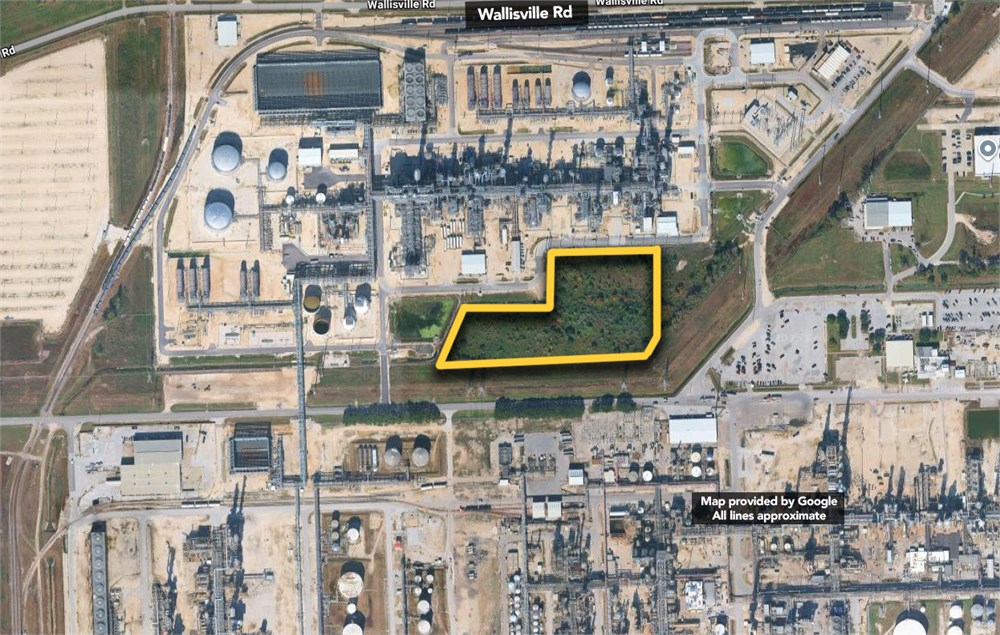
BEING 7.1352 acres of land located in the August Peterson Survey, Abstract No. 1530, Harris County, Texas, and being a portion of a 78.3743 acre tract (Tract Two), called to contain 78.486 acres, conveyed to Exxon Corporation by General Warranty Deed dated November 19, 1987 and recorded under County Clerk's File No. L440853, Film Code No. 198-37-1410 of the Official Public Records of Real Property, Harris County, Texas, said 7.1352 acre tract being more particularly described by metes and bounds as follows: Bearing recited herein based on the description of a 38.1158 acre tract (Tract One) in said General Warranty Deed.
COMMENCING at a stone marked "EC" found marking the recognized common east corner of said August Peterson Survey and the Blunt N. Sessums Survey, Abstract No. 733 in the recognized northwest line of the Peter J. Duncan Survey, Abstract No. 232, same being the southeast corner of a 150 foot wide fee strip
conveyed to Houston Lighting & Power Company (H.L.&P. Co.) by instrument recorded in [Volume 3071, Page 71] of the Deed Records of Harris County, Texas (D.R.H.C.T.), and same also being the northeast corner of another 150 foot wide fee strip called to contain 9.617 acres of land conveyed to H.L.& P. Co. by instrument recorded in Volume 2379, Page 514 of said D.R.H.C.T.; THENCE South 89°02'32" West, along the common line between said H.L.V. Co. 150 foot wide fee strips, same being the recognized common line between said August Peterson Survey and said Blunt N. Sessums Survey, a distance of 208.20 feet to a chain link fence corner found marking the southwest corner of said H.L.& P. Co. fee strip (Volume 3071, Page 71 D.R.H.C.T.) and the most southerly southeast corner of the residue of said 78.3743 acre tract, same being the southeast corner and PLACE OF BEGINNING of the herein described tract; THENCE South 89°02'32" West, along the common line between said 9.617 acre tract and the residue of said 78.3743 acre tract, same being the common line between said August Peterson Survey and said Blunt N. Sessums Survey, a distance of 920.90 feet to the southwest corner of the herein described tract; THENCE North 24°36'08" East, a distance of 269.82 feet to the most westerly northwest corner of the herein described tract; THENCE North 89°40'33" East, a distance of 381.19 feet to an interior corner of the herein described tract; THENCE North 00°05'45" West, a distance of 228.32 feet to the most northerly northwest corner of the described tract; THENCE South 89°54'09" East, a distance of 440.69 feet to a 1/ 2 -inch iron rod found marking the northeast corner of the herein described tract, same being the northwest corner of a Cowboy Pipeline Company 1.7957 acre tract, same also being an interior corner of the residue of said 78.3743 acre tract; THENCE South 00°38'51" East, along the west line of said 1.7957 acre tract a distance of 440.32 feet to a chain link fence corner found marking the southwest corner of said 1.7957 acre tract, same being a southeasterly corner of the residue of said 78.3743 acre tract in the northwesterly line of said H.L.& P. Co. 150 foot wide fee strip described by said instrument recorded in Volume 3071, Page 71 of said Deed Records; THENCE South 42°57'020 West, along a chain link fence marking the common line between said 150 foot wide H.L.& P. Co. fee strip and the residue of said 78.3743 acre tract, a distance of 26.46 feet to the PLACE OF BEGINNING and containing 7.1352 acres of land.
- "As-Is, Where-is", no contingencies to sale
- Close within 30 days of seller acceptance
- 5% Buyer's Premium
- 10% Down Payment ($5000 minimum)
- Technology Fee: $299
- View full Terms of Sale
To learn more about auction, visit Help Center or our Frequently Asked Questions.
You can also speak with Customer Service during business hours, call 866.921.2135 or email us.