


 Print
Print Save
Save
 Share
Share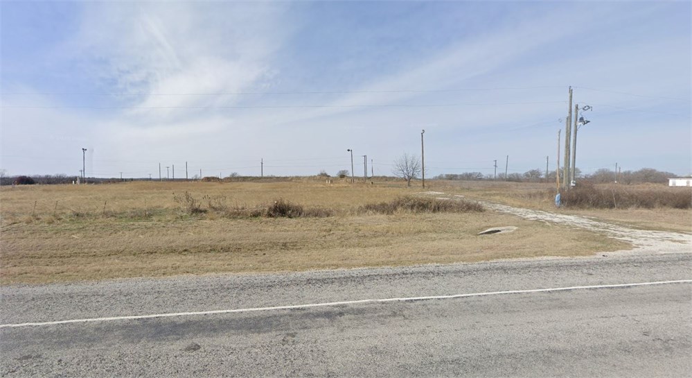
Open Public Inspections: View at your convenience during daylight hours.
- DO NOT BID unless you have read the Williams & Williams Terms & Conditions of Sale, the Contract for Sale, Property Disclosures, all available due diligence materials, and the Auction Day Notes for each property. BY PLACING YOUR BID, YOU AGREE TO BE BOUND BY THE PROPERTY SPECIFIC CONTRACT FOR SALE, DISCLOSURES, AUCTION DAY NOTES, AND THE WILLIAMS & WILLIAMS TERMS & CONDITIONS OF SALE.
- All properties are sold "AS IS, WHERE IS" with no financing, inspection or other contingencies to sale.
- Escrow. Buyer acknowledges receipt of the Joint Escrow Instructions that modifies the Contract for Sale to provide for a designated Escrow Agent to hold down payment funds. Buyer and Seller agree that the Escrow funds may be held in a trust/escrow account located outside of the state where the Property is located.
- Property Tax Disclosure Summary: Buyer Should Not Rely On The Seller's Current Property Taxes As The Amount Of Property Taxes That The Buyer May Be Obligated To Pay In The Year Subsequent To The Purchase. A Change Of Ownership Or Property Improvements Triggers Reassessments Of The Property That Could Result In Higher Property Taxes. If You Have Any Questions Concerning Valuation, Contact Property Appraiser's Office For Information.
- Square Footage/Acreage Disclosure. The source of the square footage or acreage represented for the property is from public record. Buyer understands and acknowledges that square footage or acreage measurements of a property can vary from a few feet to several hundred feet regardless of source (County Assessor's records, appraisal or appraisal measurement report, survey, etc.). Buyer shall be solely responsible for satisfying that the size and/or square footage or acreage of the property is acceptable to the Buyer.
- Personal Property Not Included. Only title to the real estate is being conveyed. Personal property may be present, but is not included in the auction. Removal of personal property remaining on site at the time of closing is the responsibility of the Buyer.
- Zone, Code, and Use Disclosure. Buyer acknowledges that the Property shall be purchased "AS-IS, WHEREIS, WITH ALL FAULTS." The Property may be subject to city, village, and/or county code or zoning violations, and Buyer accepts the property subject to any such violations. Buyer agrees to conduct an independent search of all property records in the city, county, and/or village prior to bidding and has bid accordingly. Buyer shall be responsible for any and all required remediation of the property, if any. Buyer shall not rely on any information provided by the Seller or Williams & Williams regarding the status of any code or zoning violations, and shall base its decisions on its independent inspection. Buyer also acknowledges that the property may be subject to city, village, and/or county occupancy regulations and requirements which may impact the current and/or future use of the properties. Buyer acknowledges that the seller and Williams & Williams make no warranties of any nature, express or implied, as to the permitted uses of the property, and any prohibition of buyer's intended use of the property shall not be a grounds for terminating the contract.
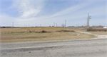
- Pictures may not reflect specific parcel, entire parcel, or current conditions of any structures that are present.
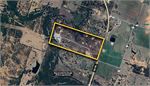
Legal description of land:
TRACT ONE: ALL THAT CERTAIN TRACT OR PARCEL OF LAND BEING A PART OF THE SOUTH HALF OF SUBDIVISION #18 OF THE J.P. STEPHENSON SURVEY IN COMANCHE COUNTY, TEXAS, AND DESCRIBED AS FOLLOWS: BEGINNING AT A POINT IN THE SOUTH LINE OF SUBDIVISION #18 2098 FEET FROM ITS SOUTHEAST CORNER; THENCE WITH THE SOUTH LINE OF SAID SUBDIVISION #18; THENCE NORTH 71 DEGREES 05 MINUTES WEST 1000 FEET TO A STONE THE SOUTHWEST CORNER OF SAID #18; THENCE NORTH 18 DEGREES 45 MINUTES EAST 1425 FEET TO A STONE MOUND; THENCE SOUTH 70 DEGREES 50 MINUTES EAST 1000 FEET TO A STAKE; THENCE SOUTH 18 DEGREES 45 MINUTES WEST 1422 FEET TO THE BEGINNING, CONTAINING 32.7 ACRES, MORE OR LESS, BEING A PORTION OF THE LAND ACQUIRED BY DEED DATED NOVEMBER 6, 1918, EXECUTED BY O. A. RIDDLE, ET US TO TRUSTEES OF MAGNOLIA PETROLEUM COMPANY RECORDED IN VOL. 126, PAGE 118 RECORDS OF COMANCHE COUNTY, TEXAS, TO WHICH REFERENCE IS MADE.
AND
TRACT TWO: ALL THAT CERTAIN LOT, TRACT OR PARCEL OF LAND SITUATED IN COMANCHE COUNTY, TEXAS, BEING A PART OF ONE LEAGUE AND LABOR SURVEY PATENTED TO JAMES B. SHAW, ASSIGNEE OF J.P. STEVENSON BY PATENT DATED MARCH 26, 1855, BY PATENT NO. 137, VOL. 12, AND BEING A PART OF THE SOUTH 1/2 OF SUBDIVISION NO. 18, OF SAID SURVEY, AND A PART OF THAT CERTAIN 100 ACRE TRACT DESCRIBED IN A DEED FROM O.A. RIDDLE AND WIFE TO MAGNOLIA PETROLEUM COMPANY, DATED NOVEMBER 6, 1918, AND RECORDED IN BOOK 126, PAGE 118, OF THE DEED RECORDS OF COMANCHE COUNTY, TEXAS, THE LAND HEREIN CONVEYED BEING MORE DEFINITELY DESCRIBED AS FOLLOWS: BEGINNING AT A POINT IN THE SOUTH LINE OF SUBDIVISION NO. 18 OF SAID STEVENSON SURVEY AT A POINT 1098 FEET FROM A STONE MOUND AT EH SOUTHEAST CORNER OF SAID 100 ACRE TRACT, WHICH POINT IS AT THE SOUTHEAST CORNER OF A TRACT OF 32.7 ACRES HERETOFORE DEEDED BY MAGNOLIA PETROLEUM COMPANY TO MAGNOLIA PIPE LINE COMPANY; THENCE WITH THE EAST LINE OF SAID 32.7 ACRE TRACT NORTH 18 DEG. 45' EAST 1050 FEET A STAKE FOR CORNER; THENCE SOUTH 71 EAST 700 FEET A STAKE FOR CORNER; THENCE SOUTH 18 DEG. 45' WEST 1050 FEET TO THE SOUTH LINE OF MAGNOLIA PETROLEUM COMPANY'S PROPERTY AND WITH THE SOUTH LINE OF SAME NORTH 71 DEG. 5' WEST 700 FEET TO THE PLACE OF BEGINNING, CONTAINING 16.87 ACRES OF LAND.
AND
TRACT THREE: ALL THAT CERTAIN LOT, TRACT OR PARCEL OF LAND, BEING 50.34 ACRES IN THE SOUTH HALF (S1/2) OF THE J.P. STEVENSON SURVEY, COMANCHE COUNTY, TEXAS, AND BEING MORE PARTICULARLY DESCRIBED AS FOLLOWS:
BEGINNING AT THE SOUTHEAST CORNER OF THE SOUTH HALF (S1/2) OF SUBDIVISION 18 OF THE J.P. STEVENSON SURVEY, COMANCHE COUNTY, TEXAS;
THENCE NORTH 17 DEG. 51' EAST, 1405.1 FEET TO THE NORTHEAST CORNER OF SAID SOUTH HALF (S1/2) OF SUBDIVISION 18;
THENCE NORTH 71 DEG. 40' WEST, 2113.5 FEET WITH THE NORTH LINE OF SAID SOUTH HALF (S1/2) OF SUBDIVISION 18 TO THE NORTHEAST CORNER OF A 32.7-ACRE TRACT HERETOFORE DEED TO MAGNOLIA PIPE LINE COMPANY BY MAGNOLIA PETROLEUM COMPANY; THENCE SOUTH 17 DEG. 13' WEST, 357.4 FEET TO THE NORTHWEST CORNER OF A 16.87-ACRE TRACT HERETOFORE DEEDED TO MAGNOLIA PIPE LINE COMPANY BY MAGNOLIA PETROLEUM COMPANY; THENCE SOUTH 71 DEG. 51' EAST, 700 FEET WITH THE NORTH LINE OF SAID 16.87-ACRE TRACT TO ITS NORTHEAST CORNER; THENCE SOUTH 17 DEG. 13' WEST, 1050 FEET WITH THE EAST LINE OF SAID 16.87-ACRE TRACT TO ITS SOUTHEAST CORNER IN THE SOUTH LINE OF SAID SOUTH HALF (S1/2) OF SUBDIVISION 18; THENCE SOUTH 71 DEG. 51' EAST WITH THE SOUTH LINE OF SAID SOUTH HALF (S1/2) OF SUBDIVISION NO. 18, 1398 FEET TO POINT OF BEGINNING AND CONTAINING 50.34 ACRE OF LAND, MORE OR LESS.
- "As-Is, Where-is", no contingencies to sale
- Close within 30 days of seller acceptance
- 5% Buyer's Premium
- 10% Down Payment ($5000 minimum)
- Technology Fee: $299
- View full Terms of Sale
To learn more about auction, visit Help Center or our Frequently Asked Questions.
You can also speak with Customer Service during business hours, call 866.921.2135 or email us.