


 Print
Print Save
Save
 Share
Share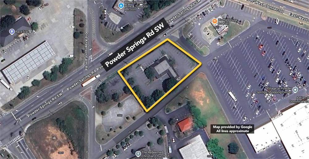
***DUE TO INCLEMENT WEATHER THE OPEN PUBLIC INSPECTION EVENT ON 1/10/25 HAS BEEN CANCELED. WE APOLOGIZE FOR ANY INCONVENIENCE***
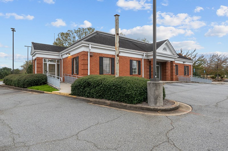
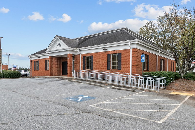
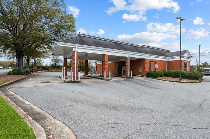
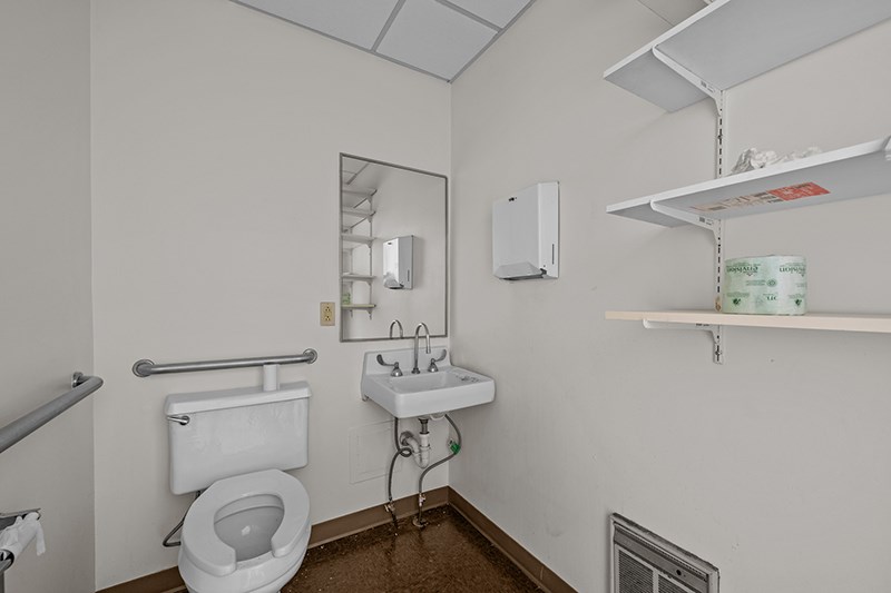
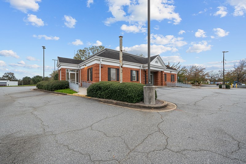
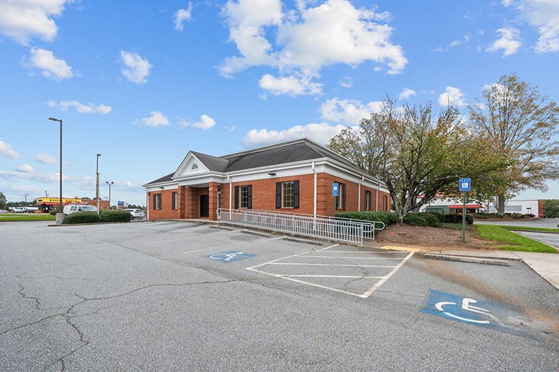
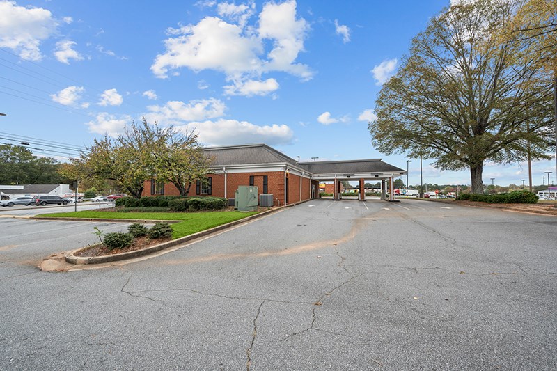
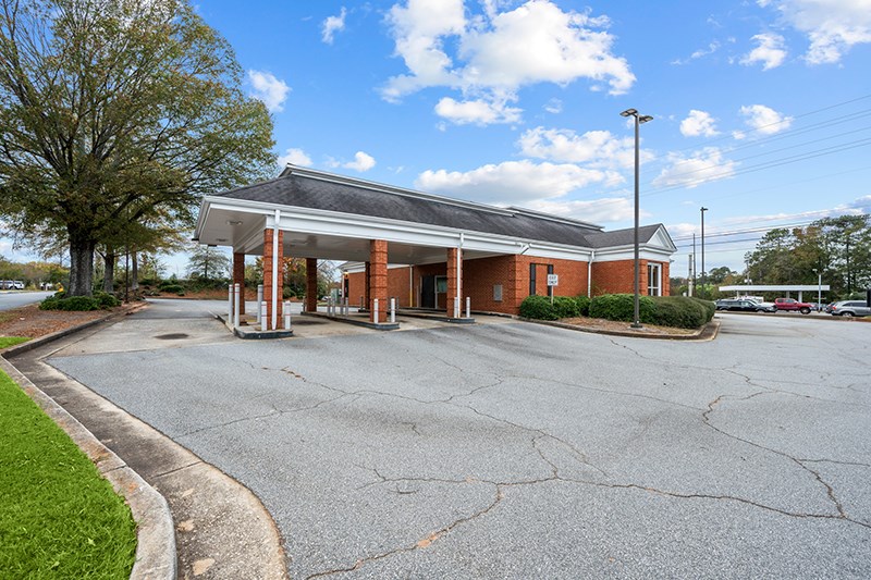
3,433+/-sf former bank building sitting on 1+/-ac built in 1988. Easy access to Ernest W Barrett Pkwy SW with approx. 290 feet of frontage on Powder Springs Rd.
Open Public Inspections: 11-2pm Wednesday December 18
• Due diligence materials (environmental, survey, title, contract, etc.) available under cover of CNRA.
• See “Closing Costs” paragraph of the Contract for additional closing costs associated with this property.
· Deed Restriction Disclosure. Buyer understands that Seller will convey a warranty deed to the Property that includes use restrictions. Buyer acknowledges receipt of deed restriction document titled ‘Declaration of Restrictions’ and agrees to accept the conveyance document that includes the terms, conditions and restrictions set forth therein.
• Buyer acknowledges that Bank of America employees and their spouse, domestic partners, dependent children and business entities in which an employee has an interest are prohibited from purchasing the properties.
• No Buyer Broker compensation will be offered
• DO NOT BID unless you have read the Williams & Williams Terms & Conditions of Sale, the Contract for Sale, Property Disclosures, all available due diligence materials, and the Auction Day Notes for each property. BY PLACING YOUR BID, YOU AGREE TO BE BOUND BY THE PROPERTY SPECIFIC CONTRACT FOR SALE, DISCLOSURES, AUCTION DAY NOTES, AND THE WILLIAMS & WILLIAMS TERMS & CONDITIONS OF SALE.
• All properties are sold "AS IS, WHERE IS" with no financing, inspection or other contingencies to sale.
• Escrow. Buyer acknowledges receipt of the Joint Escrow Instructions that modifies the Contract for Sale to provide for a designated Escrow Agent to hold down payment funds. Buyer and Seller agree that the Escrow funds may be held in a trust/escrow account located outside of the state where the Property is located.
· Property Tax Disclosure Summary: Buyer Should Not Rely On The Seller’s Current Property Taxes As The Amount Of Property Taxes That The Buyer May Be Obligated To Pay In The Year Subsequent To The Purchase. A Change Of Ownership Or Property Improvements Triggers Reassessments Of The Property That Could Result In Higher Property Taxes. If You Have Any Questions Concerning Valuation, Contact Property Appraiser’s Office For Information.
· Square Footage/Acreage Disclosure. The source of the square footage or acreage represented for the property is from public record. Buyer understands and acknowledges that square footage or acreage measurements of a property can vary from a few feet to several hundred feet regardless of source (County Assessor’s records, appraisal or appraisal measurement report, survey, etc.). Buyer shall be solely responsible for satisfying that the size and/or square footage or acreage of the property is acceptable to the Buyer.
• Personal Property Not Included. Only title to the real estate is being conveyed. Personal property may be present, but is not included in the auction. Removal of personal property remaining on site at the time of closing is the responsibility of the Buyer.
· Zone, Code, and Use Disclosure. Buyer acknowledges that the Property shall be purchased “AS-IS, WHEREIS, WITH ALL FAULTS.” The Property may be subject to city, village, and/or county code or zoning violations, and Buyer accepts the property subject to any such violations. Buyer agrees to conduct an independent search of all property records in the city, county, and/or village prior to bidding and has bid accordingly. Buyer shall be responsible for any and all required remediation of the property, if any. Buyer shall not rely on any information provided by the Seller or Williams & Williams regarding the status of any code or zoning violations, and shall base its decisions on its independent inspection. Buyer also acknowledges that the property may be subject to city, village, and/or county occupancy regulations and requirements which may impact the current and/or future use of the properties. Buyer acknowledges that the seller and Williams & Williams make no warranties of any nature, express or implied, as to the permitted uses of the property, and any prohibition of buyer’s intended use of the property shall not be a grounds for terminating the contract.
• Pictures may not reflect specific parcel, entire parcel, or current conditions of any structures that are present.
TRACT 1 ALL THAT TRACT OR PARCEL OF LAND LYING AND BEING IN LAND LOT 789 OF THE 19TH DISTRICT, 2ND SECTION OF COBB COUNTY, GEORGIA, WHICH TRACT IS BEING MORE PARTICULARLY DESCRIBED AS FOLLOWS: BEGINNING AT A POINT LOCATED AT THE INTERSECTION OF THE SOUTHEASTERLY RIGHT-OF-WAY LINE OF POWDER SPRINGS ROAD (100 FOOT RIGHT-OF-WAY) AND THE EASTERLY RIGHT-OF-WAY LINE OF ANDERSON FARM ROAD (50 FOOT RIGHT-OF-WAY); THENCE RUNNING ALONG THE SOUTHEASTERLY RIGHT-OF-WAY LINE OF POWDER SPRINGS ROAD NORTH 56 DEGREES 37 MINUTES 18 SECONDS EAST A DISTANCE OF 295.00 FEET TO A POINT LOCATED ON SAID SOUTHEASTERLY RIGHT-OF-WAY LINE; THENCE LEAVING THE SOUTHEASTERLY RIGHT-OF-WAY LINE OF
POWDER SPRINGS ROAD AND RUNNING SOUTH 47 DEGREES 52 MINUTES 42 SECONDS EAST A DISTANCE OF 147.00 FEET TO A POINT; THENCE SOUTH 49 DEGREES 58 MINUTES 27 SECONDS WEST A DISTANCE OF 206.83 FEET TO A POINT; THENCE SOUTH 53 DEGREES 30 MINUTES 07 SECONDS WEST A DISTANCE OF 32.00 FEET TO A POINT;
THENCE NORTH 32 DEGREES 47 MINUTES 32 SECONDS WEST A DISTANCE OF 76.50 FEET TO A POINT; THENCE
SOUTH 56 DEGREES 48 MINUTES 17 SECONDS WEST A DISTANCE OF 156.46 FEET TO A POINT LOCATED ON THE EASTERLY RIGHT-OF-WAY LINE OF ANDERSON FARM ROAD; THENCE ALONG SAID EASTERLY RIGHT-OF-WAY LINE NORTH 00 DEGREES 34 MINUTES 07 SECONDS EAST A DISTANCE OF 109.70 FEET TO A POINT LOCATED ON SAID EASTERLY RIGHT-OF-WAY LINE WHERE IT INTERSECTS WITH THE SOUTHEASTERLY RIGHT-OF-WAY LINE OF POWDER SPRINGS ROAD, SAID POINT ALSO BEING THE POINT OF BEGINNING, AS PER RECORD DRAWING OF THE POWDER SPRINGS SHOPPING CENTER FOR BARRY F. O'NEILL, PRINCIPAL MUTUAL LIFE INSURANCE COMPANY AND CHICAGO TITLE INSURANCE COMPANY DATED NOVEMBER 30, 1988, BEING LAST REVISED APRIL 18, 1989, PREPARED BY Q-B ENGINEERING AND SURVEYING, INC. AND BEARING THE CERTIFICATION OF DANIEL F. CONROY, GEORGIA REGISTERED LAND SURVEYOR NO. 2350. LESS AND EXCEPT FROM TRACT 1 THE FOLLOWING TWO (2) PARCELS: (A) PROPERTY CONVEYED IN RIGHT-OF-WAY DEED FROM NATIONSBANK OF GEORGIA, N.A. TO COBB COUNTY DEPARTMENT OF TRANSPORTATION, DATED JANUARY 31, 1995, FILED FOR RECORD FEBRUARY 6, 1995, AND RECORDED IN DEED BOOK 8716, PAGE 24, COBB COUNTY, GEORGIA RECORDS. (B) PROPERTY CONVEYED IN RIGHT-OF-WAY DEED FROM BARRY F. O'NEILL TO COBB COUNTY DEPARTMENT OF TRANSPORTATION, DATED FEBRUARY 28, 1995, FILED FOR RECORD APRIL 10, 1995, AND RECORDED IN DEED BOOK 8808, PAGE 492, AFORESAID RECORDS. TRACT 2: EASEMENTS AND OTHER INTERESTS IN REAL PROPERTY CONTAINED IN DECLARATION OF RECIPROCAL EASEMENTS AND RESTRICTIONS BY BARRY F. O'NEIL, DATED AUGUST 7, 1986, FILED FOR RECORD AUGUST 12, 1986, AND RECORDED IN DEED BOOK 4069, PAGE 287, COBB COUNTY, GEORGIA RECORDS; AS AMENDED BY FIRST AMENDMENT TO DECLARATION OF RECIPROCAL EASEMENTS AND RESTRICTIONS BY BARRY F. O'NEIL AND BARNETT BANK OF ATLANTA, DATED APRIL 27, 1989, FILED FOR RECORD MAY 25, 1989, AND RECORDED IN DEED BOOK 5349, PAGE 429, AFORESAID RECORDS. TRACT 3: EASEMENTS AND OTHER INTERESTS IN REAL PROPERTY CONTAINED IN SANITARY SEWER EASEMENT BETWEEN B. WILMONT WILLIAMS, A GEORGIA RESIDENT AND CENTER CONCEPTS, INC., A GEORGIA CORPORATION, DATED JUNE 10, 1986, FILED FOR RECORD AUGUST 12, 1986, AND RECORDED IN DEED BOOK 4069, PAGE 303, AFORESAID RECORDS; AS ASSIGNED BY ASSIGNMENT OF SEWER EASEMENT RIGHTS FROM CENTER CONCEPTS, INC., A GEORGIA CORPORATION TO DOUGLAS R. WHITE AND DONALD L. TOMBERLIN, DATED AUGUST 5, 1986, FILED FOR RECORD AUGUST 12, 1986, AND RECORDED IN DEED BOOK 4069, PAGE 306, AFORESAID RECORDS; AS ASSIGNED BY ASSIGNMENT OF SEWER EASEMENT RIGHTS FROM DOUGLAS R. WHITE AND DONALD L. TOMBERLIN TO C.P.S. ASSOCIATES, LTD., A GEORGIA LIMITED PARTNERSHIP DATED AUGUST 6, 1986, FILED FOR RECORD AUGUST 12, 1986, AND RECORDED IN DEED BOOK 4069, PAGE 311, AFORESAID RECORDS; AS ASSIGNED BY ASSIGNMENT OF SEWER EASEMENT RIGHTS BY AND BETWEEN C.P.S. ASSOCIATES, LTD., A GEORGIA LIMITED PARTNERSHIP AND BARRY F. O'NEILL, DATED AUGUST 7, 1986, FILED FOR RECORD AUGUST 12, 1986, AND RECORDED IN DEED BOOK 4069, PAGE 317, AFORESAID RECORDS. TRACT 4: EASEMENTS AND OTHER INTERESTS IN REAL PROPERTY CONTAINED IN DRAINAGE EASEMENT FROM BARRY F. O'NEILL TO THE CITIZENS AND SOUTHERN NATIONAL BANK, DATED JANUARY 25, 1989, FILED FOR RECORD MAY 25, 1989, AND RECORDED IN DEED BOOK 5349, PAGE 442, AFORESAID RECORDS.
- "As-Is, Where-is", no contingencies to sale
- 5% Buyer's Premium
- 10% Down-payment ($5,000 minimum)
- View full Terms of Sale
To learn more about auction, visit Help Center or our Frequently Asked Questions.
You can also speak with Customer Service during business hours, call 866.921.2135 or email us.