

 Print
Print Save
Save
 Share
Share
Open Public Inspections: View at your convenience during daylight hours.
- Flood Plain Disclosure. Buyer acknowledges and understands that the Property may lie in a flood zone. Buyer is purchasing the Property as-is, where-is, and accepts all responsibility at buyer's sole expense for any remediation, fees, or terms required as a result of the Property being within a flood plain.
- DO NOT BID unless you have read the Williams & Williams Terms and Conditions of Sale, the Contract for Sale, Property Disclosures, all available due diligence materials, and the Auction Day Notes for each property. BY PLACING YOUR BID, YOU AGREE TO BE BOUND BY THE PROPERTY SPECIFIC CONTRACT FOR SALE, DISCLOSURES, AUCTION DAY NOTES, AND THE WILLIAMS & WILLIAMS TERMS and CONDITIONS OF SALE.
- All properties are sold AS IS, WHERE IS with no financing, inspection or other contingencies to sale.
- Utility Easement Disclosure. Buyer understands and acknowledges that based on survey information, a utility easement located on the Property. Buyer should investigate and determine property boundaries prior to bidding. Buyer agrees to accept in 'as-is, where-is' condition, and accepts all responsibility for any encroachment, including any and all remediation, costs, or fees associated with said encroachment.
- Escrow. Buyer acknowledges receipt of the Joint Escrow Instructions that modifies the Contract for Sale to provide for a designated Escrow Agent to hold down payment funds. Buyer and Seller agree that the Escrow funds may be held in a trust/escrow account located outside of the state where the Property is located.
- Property Tax Disclosure Summary: Buyer Should Not Rely On The Seller's Current Property Taxes As The Amount Of Property Taxes That The Buyer May Be Obligated To Pay In The Year Subsequent To The Purchase. A Change Of Ownership Or Property Improvements Triggers Reassessments Of The Property That Could Result In Higher Property Taxes. If You Have Any Questions Concerning Valuation, Contact Property Appraiser's Office For Information.
- Square Footage/Acreage Disclosure. The source of the square footage or acreage represented for the property is from public record. Buyer understands and acknowledges that square footage or acreage measurements of a property can vary from a few feet to several hundred feet regardless of source (County Assessor's records, appraisal or appraisal measurement report, survey, etc.). Buyer shall be solely responsible for satisfying that the size and/or square footage or acreage of the property is acceptable to the Buyer.
- Personal Property Not Included. Only title to the real estate is being conveyed. Personal property may be present, but is not included in the auction. Removal of personal property remaining on site at the time of closing is the responsibility of the Buyer.
- Zone, Code, and Use Disclosure. Buyer acknowledges that the Property shall be purchased AS-IS, WHERE-IS, WITH ALL FAULTS. The Property may be subject to city, village, and/or county code or zoning violations, and Buyer accepts the property subject to any such violations. Buyer agrees to conduct an independent search of all property records in the city, county, and/or village prior to bidding and has bid accordingly. Buyer shall be responsible for any and all required remediation of the property, if any. Buyer shall not rely on any information provided by the Seller or Williams & Williams regarding the status of any code or zoning violations, and shall base its decisions on its independent inspection. Buyer also acknowledges that the property may be subject to city, village, and/or county occupancy regulations and requirements which may impact the current and/or future use of the properties. Buyer acknowledges that the seller and Williams & Williams make no warranties of any nature, express or implied, as to the permitted uses of the property, and any prohibition of buyer's intended use of the property shall not be a grounds for terminating the contract.
- Pictures may not reflect specific parcel, entire parcel, or current conditions of any structures that are present.
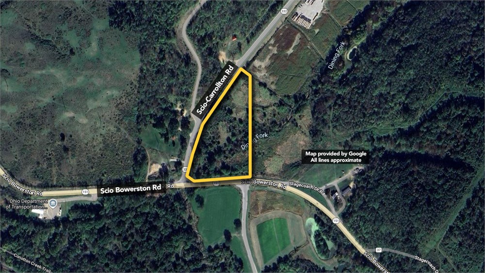
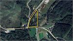
SITUATED IN THE TOWNSHIP OF NORTH, COUNTY OF HARRISON AND THE STATE OF OHIO: BEING LOCATED IN THE WEST HALF OF SECTION 32 IN NW TOWNSHIP 12, RANGE 5 AND IN THE EAST HALF OF NE SECTION 2 IN TOWNSHIP 13, RANGE 6 AND BEING PART OF A 107.262 ACRE TRACT (BY AUDITOR) (FOUND BY SURVEY TO CONTAIN 110.190 ACRES) PARCEL NO. 20-00698.000 LOCATED IN SAID WEST HALF OF SECTION 32 AND BEING PART OF A 8.50 ACRE TRACT (BY AUDITOR) (FOUND BY SURVEY TO CONTAIN 8.075 ACRES) PARCEL NO. 20-00241.000 LOCATED IN SAID EAST HALF OF SECTION 2 CONVEYED TO JODY AND RICHARD SNYDER AS RECORDED IN VOLUME 139 AT PAGE 477 OF THE HARRISON COUNTY DEED RECORDS AND BEING MORE FULLY DESCRIBED AS FOLLOWS:
BEGINNING AT AN IRON PIPE FOUND ON THE BOUNDS OF THE SAID 107.262 ACRE TRACT, AT THE SOUTHEAST CORNER OF A 41.241 ACRE TRACT HERETOFORE ALSO BEING CONVEYED AND AT THE NORTHWEST CORNER OF A 78.968 ACRE TRACT (BY AUDITOR) CONVEYED TO THE VILLAGE OF SCIO (VOL. 201, PAGE 271); SAID POINT BEING LOCATED SOUTH 04 DEG. 45 MIN. 45 SEC. WEST, 1626.51 FEET AND NORTH 85 DEG. 06 MIN. 49 SEC. WEST, 1477.71 FEET FROM A STONE FOUND AT THE NORTHEAST CORNER OF THE NORTHWEST QUARTER OF SECTION 32; THENCE FROM THIS 'TRUE PLACE OF BEGINNING" WITH THE BOUNDS OF THE SAID 107.262 ACRE TRACT, THE WEST LINE OF THE SAID 78.968 ACRE TRACT, SOUTH 6 DEG. 01 MIN. 58 SEC. WEST 446.94 FEET TO AN IRON PIN SET ON SAID BOUNDS AND SAID WEST LINE, AT THE NORTHEAST CORNER OF A 11.003 ACRE TRACT HERETOFORE ALSO BEING CONVEYED; THENCE LEAVING SAID BOUNDS AND SAID WEST LINE AND PASSING THROUGH THE SAID 107.262 ACRE TRACT WITH THE NORTH BOUNDS OF THE SAID 11.003 ACRE TRACT THE FOLLOWING THREE (3) COURSES: 1) NORTH 83 DEG. 58 MIN. 02 SEC. WEST, 440.25 FEET TO AN IRON PIN SET; 2) THENCE SOUTH 61 DEG. 28 MIN. 28 SEC. WEST, 249.00 FEET TO AN IRON PIN SET; 3) THENCE SOUTH 68 DEG. 08 MIN. 17 SEC. WEST, 268.51 FEET (PASSING ON LINE A RAILROAD SPIKE SET AT 162.67 FEET) TO A POINT IN STATE ROUTE 151, AT THE NORTHWEST CORNER OF THE SAID 11.003 ACRE TRACT, ON THE SOUTH BOUNDS OF THE SAID 107.262 ACRE TRACT AND ON THE BOUNDS OF A 19.567 ACRE TRACT CONVEYED TO ROBERT HENDRICKS (VOL. 26, PAGE 715); THENCE WITH SAID STATE ROUTE 151, THE SOUTH BOUNDS OF THE SAID 107.262 ACRE TRACT AND THE BOUNDS OF THE SAID 19.567 ACRE TRACT WITH A CURVE TO THE LEFT HAVING A RADIUS OF 923.46 FEET, AN ARC LENGTH OF 578.31 FEET, A TANGENT OF 298.99 FEET, A CENTRAL ANGLE OF 35 DEG. 52 MIN. 51 SEC., A CHORD BEARING OF NORTH 73 DEG. 14 MIN. 59 SEC. WEST AND A CHORD LENGTH OF 568.9 FEET TO A POINT IN SAID STATE ROUTE 151, AT THE SOUTHWEST CORNER OF THE SAID 107.262 ACRE TRACT AND AT THE SOUTHEAST CORNER OF THE SAID 8.50 ACRE TRACT, ON THE BOUNDS OF THE SAID 19.567 ACRE TRACT; THENCE CONTINUING WITH SAID STATE ROUTE 151, THE BOUNDS OF THE SAID 19.567 ACRE TRACT AND WITH THE SOUTH LINE OF THE SAID 8.50 ACRE TRACT, SOUTH 89 DEG. 22 MIN. 03 SEC. WEST, 496.00 FEET TO A POINT AT THE INTERSECTION OF SAID STATE ROUTE 151 AND STATE ROUTE 332, ON SAID BOUNDS, AT THE SOUTHWEST CORNER OF THE SAID 8.50 ACRE TRACT; THENCE WITH SAID STATE ROUTE 332 AND WITH THE WEST BOUNDS OF THE SAID 8.50 ACRE TRACT THE FOLLOWING (5) COURSES: 1) NORTH 07 DEG. 16 MIN. 40 SEC. EAST, 47.19 FEET TO A POINT 2) THENCE NORTH 16 DEG. 38 MIN. 53 SEC. EAST, 398.99 FEET TO A POINT;
3) THENCE NORTH 28 DEG. 07 MIN. 02 SEC. EAST, 196.55 FEET TO A POINT; 4) THENCE NORTH 39 DEG. 46 MIN. 03 SEC. EAST 399.20 FEET TO A POINT; 5) THENCE NORTH 43 DEG. 06 MIN. 38 SEC. EAST, 71.60 FEET TO A POINT IN SAID STATE ROUTE 332, ON THE WEST BOUNDS OF THE SAID 107.262 ACRE TRACT AND AT THE SOUTHWEST CORNER OF A 41.241 ACRE TRACT; THENCE LEAVING SAID STATE ROUTE 332 AND PASSING THROUGH THE SAID 8.50 ACRE TRACT AND THE SAID 107.262 ACRE TRACT WITH THE SOUTH BOUNDS OF THE SAID 41.241 ACRE TRACT, SOUTH 47 DEG. 40 MIN. 19 SEC. EAST, 930.67 FEET (PASSING ON LINE AN IRON PIN SET AT 29.57 FEET) TO AN IRON PIN SET ON SAID BOUNDS; THENCE CONTINUING THROUGH THE SAID 107.262 ACRE TRACT WITH SAID SOUTH BOUNDS, NORTH 81 DEG. 04 MIN. 35 SEC. EAST, 797.90 FEET TO THE "TRUE PLACE OF BEGINNING" CONTAINING 25.143 ACRES OF LAND, MORE OR LESS, BUT SUBJECT TO ALL LEGAL HIGHWAYS, RIGHT-OF-WAYS, EASEMENTS AND LEASES OF RECORDS. OF THE TOTAL ABOVE DESCRIBED 25.143 ACRE TRACT, 17.269 ACRES ARE OUT OF A 107.262 ACRE TRACT (BY AUDITOR) (FOUND BY SURVEY TO CONTAIN 110.190 ACRES) PARCEL NO. 20-00698.000 LOCATED IN THE WEST HALF OF SECTION 32 AND 7.874 ACRES ARE OUT OF A 8.50 ACRE TRACT (BY AUDITOR) (FOUND BY SURVEY TO CONTAIN 8.075 ACRES) PARCEL NO. 20-00241.000 LOCATED IN THE EAST HALF OF SECTION 2. SURVEY AND DESCRIPTION BY RONALD L. SMITH, REGISTERED SURVEYOR NO. 5324. ALL IRON PINS SET WERE 5/8" X 30" WITH CAP STAMPED RON SMITH 5324. BEARINGS WERE ORIENTED TO MAGNET NORTH. SUBJECT TO ANY AND ALL RESTRICTIONS, EXCEPTIONS, RESERVATIONS, STIPULATIONS, CONDITIONS, RIGHTS OF WAY AND EASEMENTS OF RECORD. Being the same property as conveyed from David McQuilkin and Nancy J. McQuilkin, husband and wife to Utica East Ohio Midstream LLC, dated June 26, 2014 and recorded on July 07, 2014 in Book 220 at Page 2308, Harrison County records. For informational purposes only: 38150 Stagecoach Drive, Scio, OH 43988. Tax Parcel # 200000241000
- "As-Is, Where-is", no contingencies to sale
- Close within 30 days of seller acceptance, unless otherwise disclosed below
- 5% Buyer's Premium ($3500 minimum)
- 10% Down Payment ($5000 minimum)
- Technology Fee: $299
- View full Terms of Sale
To learn more about auction, visit Help Center or our Frequently Asked Questions.
You can also speak with Customer Service during business hours, call 866.921.2135 or email us.