


 Print
Print Save
Save
 Share
Share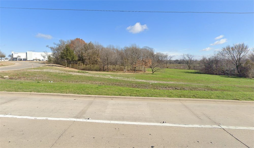
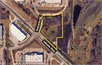
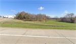
5.41+/-ac of commercial land.
Open Public Inspections: Property can be viewed at your convenience during daylight hours.
• DO NOT BID unless you have read the Williams & Williams Terms & Conditions of Sale, the Contract for Sale, Property Disclosures, all available due diligence materials, and the Auction Day Notes for each property. BY PLACING YOUR BID, YOU AGREE TO BE BOUND BY THE PROPERTY SPECIFIC CONTRACT FOR SALE, DISCLOSURES, AUCTION DAY NOTES, AND THE WILLIAMS & WILLIAMS TERMS & CONDITIONS OF SALE.
- Deed Restriction Disclosure. Buyer understands that Seller will convey a warranty deed to the Property that includes use restrictions. Buyer acknowledges receipt of deed restriction document titled ‘Declaration of Restrictions’ and agrees to accept the conveyance document that includes the terms, conditions and restrictions set forth therein.
• All properties are sold "AS IS, WHERE IS" with no financing, inspection or other contingencies to sale.
• Escrow. Buyer acknowledges receipt of the Joint Escrow Instructions that modifies the Contract for Sale to provide for a designated Escrow Agent to hold down payment funds. Buyer and Seller agree that the Escrow funds may be held in a trust/escrow account located outside of the state where the Property is located.
· Property Tax Disclosure Summary: Buyer Should Not Rely On The Seller’s Current Property Taxes As The Amount Of Property Taxes That The Buyer May Be Obligated To Pay In The Year Subsequent To The Purchase. A Change Of Ownership Or Property Improvements Triggers Reassessments Of The Property That Could Result In Higher Property Taxes. If You Have Any Questions Concerning Valuation, Contact Property Appraiser’s Office For Information.
· Square Footage/Acreage Disclosure. The source of the square footage or acreage represented for the property is from public record. Buyer understands and acknowledges that square footage or acreage measurements of a property can vary from a few feet to several hundred feet regardless of source (County Assessor’s records, appraisal or appraisal measurement report, survey, etc.). Buyer shall be solely responsible for satisfying that the size and/or square footage or acreage of the property is acceptable to the Buyer.
• Personal Property Not Included. Only title to the real estate is being conveyed. Personal property may be present, but is not included in the auction. Removal of personal property remaining on site at the time of closing is the responsibility of the Buyer.
· Zone, Code, and Use Disclosure. Buyer acknowledges that the Property shall be purchased “AS-IS, WHEREIS, WITH ALL FAULTS.” The Property may be subject to city, village, and/or county code or zoning violations, and Buyer accepts the property subject to any such violations. Buyer agrees to conduct an independent search of all property records in the city, county, and/or village prior to bidding and has bid accordingly. Buyer shall be responsible for any and all required remediation of the property, if any. Buyer shall not rely on any information provided by the Seller or Williams & Williams regarding the status of any code or zoning violations, and shall base its decisions on its independent inspection. Buyer also acknowledges that the property may be subject to city, village, and/or county occupancy regulations and requirements which may impact the current and/or future use of the properties. Buyer acknowledges that the seller and Williams & Williams make no warranties of any nature, express or implied, as to the permitted uses of the property, and any prohibition of buyer’s intended use of the property shall not be a grounds for terminating the contract.
• Pictures may not reflect specific parcel, entire parcel, or current conditions of any structures that are present.
· Texas law requires that auctioneers notify consumers that consumers may contact the Texas Department of Licensing and Regulation, PO Box 12157, Austin, TX 78711 or by phone at 800-803-9202 for the purpose of making a complaint regarding a Texas auction.
· Texas Law requires all real estate license holders to give the following information about brokerage services to prospective buyers, tenants, sellers and landlords. This information is available in the Helpful Tools & Links section.
A tract of land out of the J.C. Moffatt Survey, Abstract No. 1797, Dallas County, Texas, and being more particularly described by metes and bounds as follows: Beginning at a 1/2" found iron rod with a yellow plastic cap stamped "HALFF Assoc. Inc." (hereinafter referred to as "with cap") in the North right of way line of Lakeside Parkway (120' right of way) and the most southerly southeast corner of Lots 1 and 2, Block A, of Lakeside Trade Center, Phase 2, as recorded in Cabinet V, Page 260 of the plat records, Denton County, Texas: Thence North 39 degrees, 23 minutes, 54 seconds East, departing said North right of way line, and along the East property line of said Block A, a distance of 21.03 feet to a 1/2" iron rod set with cap for the point of curvature of a curve to the left having a radius distance of 298.00 feet, whose chord bears North 10 degrees, 51, Minutes, 39 seconds East, a distance of 284.73 feet;Thence Northeasterly, continuing along said East property line and along said curve, Through a central angle of 57 degrees, 04 minutes, 28 seconds, an arc distance of 296.85 feet to a 1/2" iron rod set with cap for the point of reverse curvature of a curve to the right having a radius distance of 44.79 feet, whose chord bears North 27 degrees 19 minutes, 25 seconds East, a distance of 63.34 feet; Thence Northerly, continuing along said east property line and along said curve through a central angle of 90 degrees, 00 minutes, 00 seconds, an arc distance of 70.36 feet to a 1/2" iron rod set with cap for the point of compound curvature of a non-tangent curve to the right having a radius distance of 195.50 feet, whose chord bears North 83 degrees, 41 minutes, 38 seconds East, a distance of 41.68 feet; Thence Easterly, continuing along said East property line and along said curve through a central angle of 12 degrees, 14 minutes, 20 seconds, an arc distance of 41.76 feet to a 1/2" iron rod set with cap for point for corner; Thence South 89 degrees, 47 minutes, 49 seconds East, continuing along said East property line a distance of 175.76 feet to a 1/2" iron rod set with cap for the point of curvature of a non-tangent curve to the left having a radius distance of 240.50 feet, whose chord bears North 77 degrees, 03 minutes, 19 seconds East, a distance of 109.42 feet; Thence Easterly, continuing along said East property line and along said curve through a central angle of 26 degrees, 17 minutes, 57 seconds, an arc distance of 110.39 feet to a 1/2" iron rod set with cap for point for corner; Thence North 63 degrees, 53 minutes, 41 seconds East, continuing along said East property line, a distance of 32.47 feet to a 1/2" iron rod set with cap for the point of curvature of a non-tangent curve to the left having a radius distance of 240.50 feet, whose chord bears North 59 degrees, 20 minutes, 25 seconds East, a distance of 38.27 feet; Thence Easterly, continuing along said curve and along said east line, through a central angle of 09 degrees, 07 minutes, 35 seconds, an arc distance of 38.31 feet to a 1/2" set iron rod with cap for the point for corner; Thence South 00 degrees, 45 minutes, 15 seconds East, departing said East property line, over and across said remainder tract, a distance of 203.12 feet to a 1/2" set iron rod with cap for corner;
Thence North 89 degrees, 48 minutes, 57 seconds East, continuing over and across said remainder tract, a distance of 8.52 feet to a 1/2" set iron rod with cap for corner; Thence South 00 degrees 13 minutes 49 seconds West, continuing over and across said remainder tract, a distance of 327.82 feet to a 1/2-inch found iron rod with cap for corner; Thence North 89 degrees, 44 minutes, 10 seconds West, continuing over and across said remainder tract, a distance of 99.84 feet to a 1/2" found iron rod with cap for corner; Thence South 00 degrees, 12 minutes, 08 seconds West, continuing over and across said remainder tract, a distance of 237.37 feet to a 1/2" found iron rod with cap for corner in said north right of way line of Lakeside Parkway; Thence North 47 degrees, 54 minutes, 24 seconds West, along said North right of way line, a distance of 527.15 feet to the point of beginning and containing 235,790 square feet or 5.413 acres of land, more or less. Note: basis of bearing for this survey is the South line of a 55.82 acre tract of land described in the plat recorded in Cabinet V, Page 260, of the plat records of Denton County, Texas, and assumed to be North 47 degrees, 54 minutes, 24 seconds West. Bearings are based on the City of Grapevine Control Monument No. 4, being reference to its Azimuth Mark (radio tower) a NAD-83 grid Azimuth of North 265 degrees, 09 minutes, 38 seconds.
- "As-Is, Where-is," no contingencies to sale
- 5% Buyer's Premium ($10,000 minimum)
- 10% Down Payment ($5,000 minimum)
- View Full Terms of Sale
To learn more about auction, visit Help Center or our Frequently Asked Questions.
You can also speak with Customer Service during business hours, call 866.921.2135 or email us.