


 Print
Print Save
Save
 Share
Share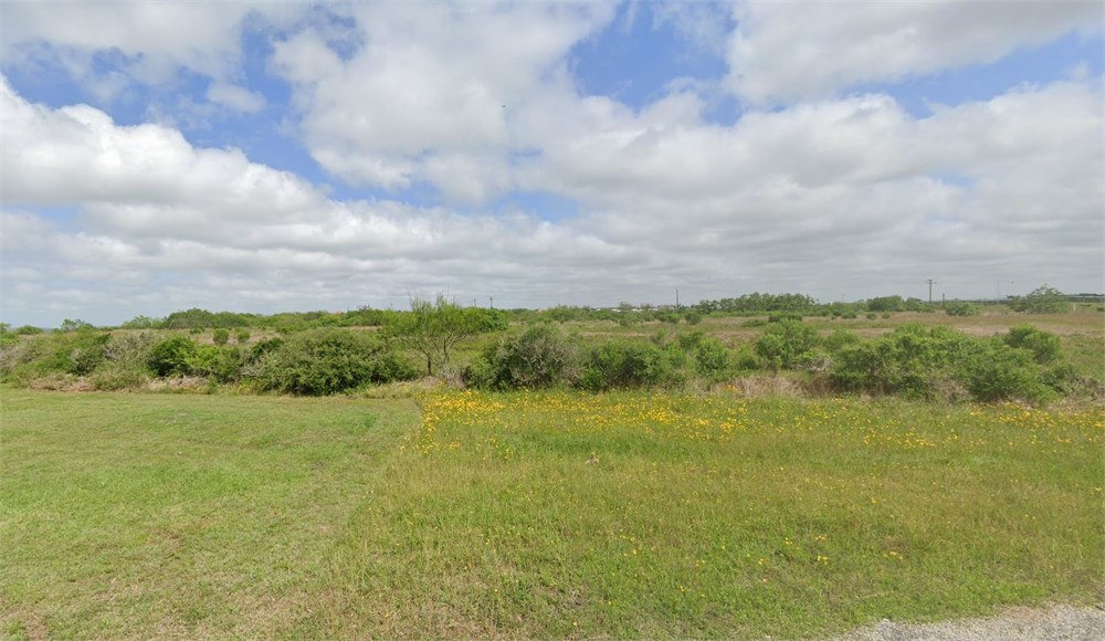
Open Public Inspections: View at your convenience during daylight hours.
- Texas law requires that auctioneers notify consumers that consumers may contact the Texas Department of Licensing and Regulation, PO Box 12157, Austin, TX 78711 or by phone at 800-803-9202 for the purpose of making a complaint regarding a Texas auction.
- Texas Law requires all real estate license holders to give the following information about brokerage services to prospective buyers, tenants, sellers and landlords. This information is available in the Documents section of the Property Detail Page on the website.
- Buyer agents welcome. Please Contact for Commission Scale.
- DO NOT BID unless you have read the Williams & Williams Terms and Conditions of Sale, the Contract for Sale, Property Disclosures, all available due diligence materials, and the Auction Day Notes for each property. BY PLACING YOUR BID, YOU AGREE TO BE BOUND BY THE PROPERTY SPECIFIC CONTRACT FOR SALE, DISCLOSURES, AUCTION DAY NOTES, AND THE WILLIAMS & WILLIAMS TERMS and CONDITIONS OF SALE.
- All properties are sold AS IS, WHERE IS with no financing, inspection or other contingencies to sale.
- Escrow. Buyer acknowledges receipt of the Joint Escrow Instructions that modifies the Contract for Sale to provide for a designated Escrow Agent to hold down payment funds. Buyer and Seller agree that the Escrow funds may be held in a trust/escrow account located outside of the state where the Property is located.
- Property Tax Disclosure Summary: Buyer Should Not Rely On The Seller's Current Property Taxes As The Amount Of Property Taxes That The Buyer May Be Obligated To Pay In The Year Subsequent To The Purchase. A Change Of Ownership Or Property Improvements Triggers Reassessments Of The Property That Could Result In Higher Property Taxes. If You Have Any Questions Concerning Valuation, Contact Property Appraiser's Office For Information.
- Square Footage/Acreage Disclosure. The source of the square footage or acreage represented for the property is from public record. Buyer understands and acknowledges that square footage or acreage measurements of a property can vary from a few feet to several hundred feet regardless of source (County Assessor's records, appraisal or appraisal measurement report, survey, etc.). Buyer shall be solely responsible for satisfying that the size and/or square footage or acreage of the property is acceptable to the Buyer.
- Personal Property Not Included. Only title to the real estate is being conveyed. Personal property may be present, but is not included in the auction. Removal of personal property remaining on site at the time of closing is the responsibility of the Buyer.
- Zone, Code, and Use Disclosure. Buyer acknowledges that the Property shall be purchased AS-IS, WHERE-IS, WITH ALL FAULTS. The Property may be subject to city, village, and/or county code or zoning violations, and Buyer accepts the property subject to any such violations. Buyer agrees to conduct an independent search of all property records in the city, county, and/or village prior to bidding and has bid accordingly. Buyer shall be responsible for any and all required remediation of the property, if any. Buyer shall not rely on any information provided by the Seller or Williams & Williams regarding the status of any code or zoning violations, and shall base its decisions on its independent inspection. Buyer also acknowledges that the property may be subject to city, village, and/or county occupancy regulations and requirements which may impact the current and/or future use of the properties. Buyer acknowledges that the seller and Williams & Williams make no warranties of any nature, express or implied, as to the permitted uses of the property, and any prohibition of buyer's intended use of the property shall not be a grounds for terminating the contract.
- Easement Disclosure. Buyer understands and acknowledges that an easement may be located on the Property. Buyer should investigate and determine property boundaries prior to bidding. Buyer agrees to accept in 'as-is, where-is' condition, and accepts all responsibility for any encroachment, including any and all remediation, costs, or fees associated with said encroachment.
- Deed Restriction Disclosure. Buyer understands that Seller will convey a warranty deed to the Property that may include use restrictions. Buyer acknowledges receipt of deed restriction document titled ‘Declaration of Restrictions’ and agrees to accept the conveyance document that includes the terms, conditions and restrictions set forth therein.
- Use Restrictions, Institutional Controls and Engineering Controls. In addition to any other Use Restrictions, the Railroad Commission of Texas (“RRC”) placed Use Restrictions (“the RRC Restrictions”) against the Property. The RRC Restrictions were recorded under Clerk’s File No. 2025-02756 of the Official Public Records of Calhoun County, Texas. The RRC Use Restrictions prohibit the use of groundwater and state that the Property is restricted to commercial use only.
- Buyer acknowledges that, in accordance with the Contract for Sale of Real Estate at Auction (the “Contract”), a Title Commitment will be prepared and provided to Buyer at or before closing. Buyer has had an opportunity to perform their own due diligence prior to auction in order to ascertain information relevant to preparation of a Title Commitment and acknowledges that such due diligence has been performed by Buyer prior to bidding. The absence of receipt of the preliminary Title Commitment prior to auction does not abrogate, change, or waive any of the agreed upon terms in the Contract including but not limited to any “Permitted Title Exceptions” as outlined in the Contract. The Closer shall provide the Title Insurance Commitment to Buyer and Seller upon completion of same.
- Pictures may not reflect specific parcel, entire parcel, or current conditions of any structures that are present.
- RESTRICTED PARTY SCREENING. Notwithstanding anything to the contrary herein, Seller shall have the right, in its sole and absolute discretion, to reject any bid or to terminate this Contract if Buyer, or any direct or indirect owner of Buyer, fails to clear Seller’s internal restricted parties screening or appears on any list administered by the Office of Foreign Assets Control of the U.S. Department of the Treasury (“OFAC”), including, without limitation, the Specially Designated Nationals and Blocked Persons List, or any similar list maintained by any governmental authority. In the event of such rejection or termination, this Agreement shall be null and void, the Down Payment shall be returned to the Buyer and neither party shall have any further obligation hereunder (except for obligations that expressly survive termination).
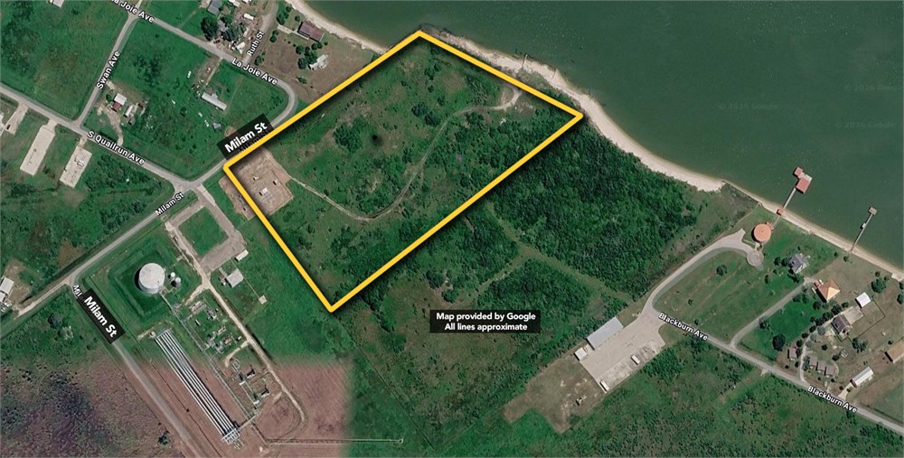
ALL of that certain 10.139 acres (441,670 square feet) of land situated in the Narciso Cavasos League, Abstract 3, Calhoun County, Texas, being that same 10 acre tract of land described in instrument to Humble Oil & Refining Company, recorded in Volume 86, Page 174, of the Calhoun County Deed Records, (C.C.D.R.); said 10.139 acres (441,670 square feet) of land being more particularly described by metes and bounds as follows (all bearings are derived from GPS session performed 09-07-11, and are based on National Geodetic Survey (NGS) reference station AN2466, being a brass disc in concrete post stamped BM NO 1 1935, elevation 3.00 feet, NAVD 1988): BEGINNING at a ¾ inch galvanized bolt found for the westerly corner of said 10 acre tract, and being in the southeasterly right-of-way of Milam Street, (70 feet wide) as shown on plat of Alamo Beach Townsite, recorded in Volume V, Page 1, of the Calhoun County Plat Records, (C.C.P.R.); THENCE North 52°04'50" East, (called 554°25'W, 715.00 feet) with the northwesterly line of said 10 acre tract, the southeasterly right-of-way of said Milam Street, at 550.00 feet pass a 5/8 inch iron rod with cap stamped "A.L. SIKES RPLS 2914" set for reference point, in all a distance of 686.52 feet, to the mean higher high water mark, a contour with the elevation of 1.2 feet, NAVD 1988 and based on said BM-1; THENCE with the meanders of said mean higher high water mark the following bearings and distances: South 81°45'01" East, 104.36 feet, South 63°09'04" East. 109.61 feet, South 89°45'35" East, 41.05 feet, South 72°15'56" East, 73.26 feet, North 84°45'40" East, 46.95 feet, South 65°27'56" East, 63.53 feet, South 25°15'39" West, 12.36 feet, South 58°33'18" East, 125.71 feet, South 42° 51'45" East, 44.13 feet, to the southeasterly line of said 10 acre tract; THENCE South 52°04'50" West, (called N54°25'E, 993.00 feet), with the southeasterly line of said 10 acre tract, at 232.28 feet pass a % inch iron rod (bent) found for point on line, at 550.00 feet pass a 5/8 inch iron rod with cap stamped "A.L. SIKES RPLS 2914" set for reference point, in all a distance of 986.14 feet, to a' inch galvanized bolt found for the southerly corner of said 10 acre tract; THENCE North 37°48'10" West, 509.16 feet, (called S35°28'E, 510.00 feet) with the southwesterly line of said 10 acre tract, to the POINT OF BEGINNING, and containing 10.139 acres (441,670 square feet) of land.
- "As-Is, Where-is", no contingencies to sale
- Close within 30 days of seller acceptance, unless otherwise disclosed below
- 5% Buyer's Premium ($10000 minimum)
- 10% Down Payment ($5000 minimum)
- Technology Fee: $299
- Buyer's Agent Commission: Please Contact for Commission Scale
- View full Terms of Sale
To learn more about auction, visit Help Center or our Frequently Asked Questions.
You can also speak with Customer Service during business hours, call 866.921.2135 or email us.