


 Print
Print Save
Save
 Share
Share
Open Public Inspections: 11-2PM Friday September 12
- DO NOT BID unless you have read the Williams & Williams Terms & Conditions of Sale, the Contract for Sale, Property Disclosures, all available due diligence materials, and the Auction Day Notes for each property. BY PLACING YOUR BID, YOU AGREE TO BE BOUND BY THE PROPERTY SPECIFIC CONTRACT FOR SALE, DISCLOSURES, AUCTION DAY NOTES, AND THE WILLIAMS & WILLIAMS TERMS & CONDITIONS OF SALE.
- All properties are sold "AS IS, WHERE IS" with no financing, inspection or other contingencies to sale.
- Escrow. Buyer acknowledges receipt of the Joint Escrow Instructions that modifies the Contract for Sale to provide for a designated Escrow Agent to hold down payment funds. Buyer and Seller agree that the Escrow funds may be held in a trust/escrow account located outside of the state where the Property is located.
- Property Tax Disclosure Summary: Buyer Should Not Rely On The Seller's Current Property Taxes As The Amount Of Property Taxes That The Buyer May Be Obligated To Pay In The Year Subsequent To The Purchase. A Change Of Ownership Or Property Improvements Triggers Reassessments Of The Property That Could Result In Higher Property Taxes. If You Have Any Questions Concerning Valuation, Contact Property Appraiser's Office For Information.
- Square Footage/Acreage Disclosure. The source of the square footage or acreage represented for the property is from public record. Buyer understands and acknowledges that square footage or acreage measurements of a property can vary from a few feet to several hundred feet regardless of source (County Assessor's records, appraisal or appraisal measurement report, survey, etc.). Buyer shall be solely responsible for satisfying that the size and/or square footage or acreage of the property is acceptable to the Buyer.
- Personal Property Not Included. Only title to the real estate is being conveyed. Personal property may be present, but is not included in the auction. Removal of personal property remaining on site at the time of closing is the responsibility of the Buyer.
- Zone, Code, and Use Disclosure. Buyer acknowledges that the Property shall be purchased "AS-IS, WHEREIS, WITH ALL FAULTS." The Property may be subject to city, village, and/or county code or zoning violations, and Buyer accepts the property subject to any such violations. Buyer agrees to conduct an independent search of all property records in the city, county, and/or village prior to bidding and has bid accordingly. Buyer shall be responsible for any and all required remediation of the property, if any. Buyer shall not rely on any information provided by the Seller or Williams & Williams regarding the status of any code or zoning violations, and shall base its decisions on its independent inspection. Buyer also acknowledges that the property may be subject to city, village, and/or county occupancy regulations and requirements which may impact the current and/or future use of the properties. Buyer acknowledges that the seller and Williams & Williams make no warranties of any nature, express or implied, as to the permitted uses of the property, and any prohibition of buyer's intended use of the property shall not be a grounds for terminating the contract.
- Pictures may not reflect specific parcel, entire parcel, or current conditions of any structures that are present.
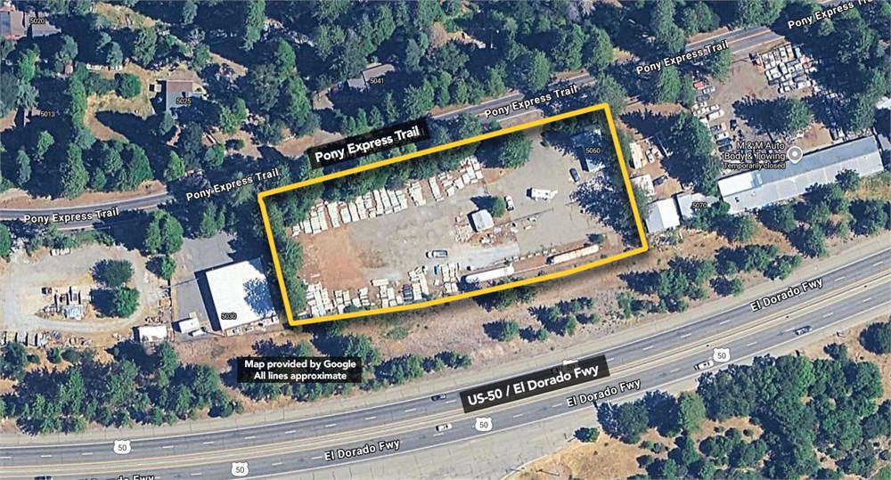
The Land referred to herein below is situated in the City of Camino, County of El Dorado, State of California, and is described as follows: All that portion of the Southeast quarter of the Southeast quarter of Section 3, Township 10 North, Range 12 East, M.D.M.&M., described as follows: Beginning at the Northwesterly corner of the tract of land herein described a 6 inch x 6 inch concrete monument located on the Southerly right of way line of Highway U.S. No. 50, from which the Northeast corner of said Southeast quarter of Southeast quarter of Section 3, bears North 80 deg. 01' East 968.43 feet; thence from the point of beginning and along said right of way line North 73 deg. 56' East 500.0 feet, the Northeasterly corner thereof, a 1 inch capped iron pipe stamped "L.S. 1820-1951'; thence
leaving said right of way line South 16 deg. 04' East 412.75 feet the Southeasterly corner thereof; thence South 72 deg. 56' West 100.0 feet, a 1 inch iron pipe with sleeve and plug; thence North 16 deg. 04' West 94.7 feet a 1 inch capped iron pipe stamped "L.S. 1820-1951"; thence South 72 deg. 26'30" West 352.73 feet a similar pipe; thence North 79 deg. 18'30" West 52.7 feet; a similar pipe; thence North 16 deg. 04' West 305.55 feet to the point of beginning. Saving and Excepting therefrom the following: Beginning at the Northeast corner of the herein described parcel, a 6 X 6 inch concrete monument on the Southerly right of way line of U.S. Highway No. 50, from which the East quarter corner of said Section 3, bears North 35 deg. 52'30" East 1761.5 feet; thence from point of beginning, along said right of way line North 73 deg. 56' East 75.0 feet, the Northeast corner, a 3/4 inch capped iron pipe; thence leaving said South line South 16 deg. 04' East 325.56 feet, the Southeast corner, a similar pipe; thence South 72 deg. 26'30" West 27.95 feet, a 1 inch capped iron pipe; thence North 79 deg. 18'30" West 52.70 feet, a similar pipe; thence North 16 deg. 04' West 305.55 feet to the point of beginning. Also Excepting therefrom that portion thereof lying Southerly from the line described as follows: Beginning at a point on the west line of said parcel of land distant thereon South 17 deg. ''' East 150.47 feet from the Northwest corner of said parcel, said point also being distant 147.16 feet Northerly measured radially from the base line at Engineer's Station "E" 451+57.91 of the Department of Public Works' Survey from 0.3 mile East of Camino to 0.7 mile East of Sly Park Road, road III-ED-II-E, F (the California State Zone II Coordinates for said point of beginning are X=2, 389,921.55 and Y+395,293.714); thence from said point of beginning leaving said West line along a curve to the left with a radius of 2600.00 feet, through an angle of 09 deg. 23'19" an arc distance of 426.04 feet (the chord of which curve bears North 76 deg. 43'27" East 425.28 feet) to appoint on the East line of said parcel distant thereon South 17 deg. 00' East 176.81 feet from the Northeast corner of said parcel of land.
- "As-Is, Where-is", no contingencies to sale
- Close within 30 days of seller acceptance
- 5% Buyer's Premium ($10000 minimum)
- 10% Down Payment ($ minimum)
- Technology Fee: $299
- View full Terms of Sale
To learn more about auction, visit Help Center or our Frequently Asked Questions.
You can also speak with Customer Service during business hours, call 866.921.2135 or email us.