

 Print
Print Save
Save
 Share
Share
Open Public Inspections: View at your convenience during daylight hours.
- DO NOT BID unless you have read the Williams & Williams Terms & Conditions of Sale, the Contract for Sale, Property Disclosures, all available due diligence materials, and the Auction Day Notes for each property. BY PLACING YOUR BID, YOU AGREE TO BE BOUND BY THE PROPERTY SPECIFIC CONTRACT FOR SALE, DISCLOSURES, AUCTION DAY NOTES, AND THE WILLIAMS & WILLIAMS TERMS & CONDITIONS OF SALE.
- All properties are sold "AS IS, WHERE IS" with no financing, inspection or other contingencies to sale.
- Escrow. Buyer acknowledges receipt of the Joint Escrow Instructions that modifies the Contract for Sale to provide for a designated Escrow Agent to hold down payment funds. Buyer and Seller agree that the Escrow funds may be held in a trust/escrow account located outside of the state where the Property is located.
- Property Tax Disclosure Summary: Buyer Should Not Rely On The Seller's Current Property Taxes As The Amount Of Property Taxes That The Buyer May Be Obligated To Pay In The Year Subsequent To The Purchase. A Change Of Ownership Or Property Improvements Triggers Reassessments Of The Property That Could Result In Higher Property Taxes. If You Have Any Questions Concerning Valuation, Contact Property Appraiser's Office For Information.
- Square Footage/Acreage Disclosure. The source of the square footage or acreage represented for the property is from public record. Buyer understands and acknowledges that square footage or acreage measurements of a property can vary from a few feet to several hundred feet regardless of source (County Assessor's records, appraisal or appraisal measurement report, survey, etc.). Buyer shall be solely responsible for satisfying that the size and/or square footage or acreage of the property is acceptable to the Buyer.
- Personal Property Not Included. Only title to the real estate is being conveyed. Personal property may be present, but is not included in the auction. Removal of personal property remaining on site at the time of closing is the responsibility of the Buyer.
- Zone, Code, and Use Disclosure. Buyer acknowledges that the Property shall be purchased "AS-IS, WHEREIS, WITH ALL FAULTS." The Property may be subject to city, village, and/or county code or zoning violations, and Buyer accepts the property subject to any such violations. Buyer agrees to conduct an independent search of all property records in the city, county, and/or village prior to bidding and has bid accordingly. Buyer shall be responsible for any and all required remediation of the property, if any. Buyer shall not rely on any information provided by the Seller or Williams & Williams regarding the status of any code or zoning violations, and shall base its decisions on its independent inspection. Buyer also acknowledges that the property may be subject to city, village, and/or county occupancy regulations and requirements which may impact the current and/or future use of the properties. Buyer acknowledges that the seller and Williams & Williams make no warranties of any nature, express or implied, as to the permitted uses of the property, and any prohibition of buyer's intended use of the property shall not be a grounds for terminating the contract.
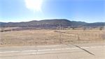
- Pictures may not reflect specific parcel, entire parcel, or current conditions of any structures that are present.
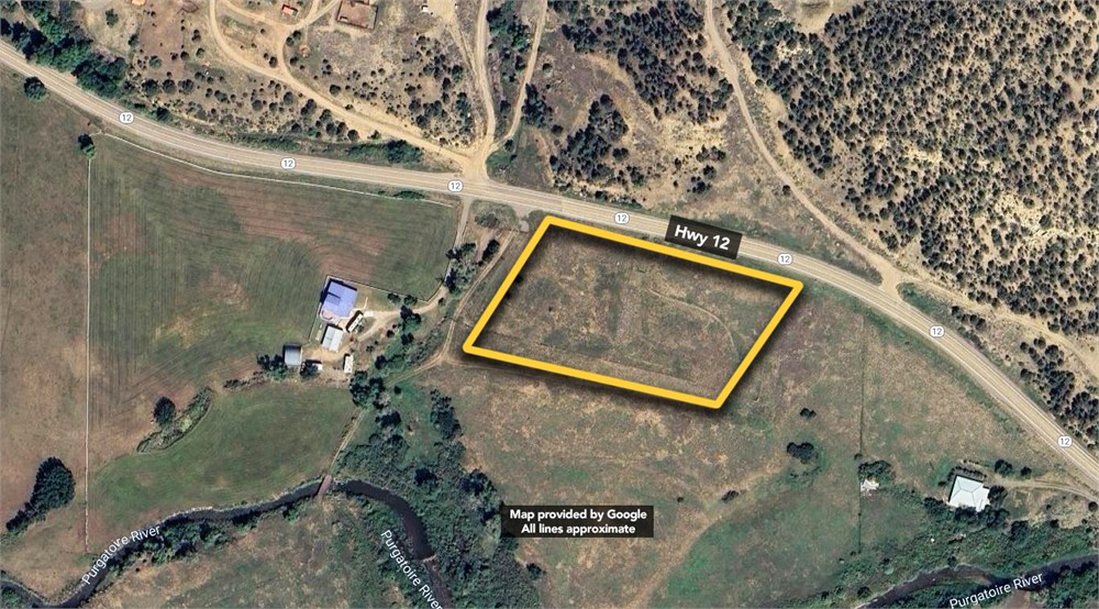
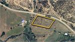
Being a 3.03-acre tract, situated in Las Animas County, State of Colorado, being out of the Southwest Quarter (SW/4) of the Southwest Quarter (SW/4) of Section 20, Township 33 South, Range 67 West, and being that same tract conveyed to XTO Energy Inc., a Delaware Corporation, in Book Number 1069, Page 703 of the Official Records of Las Animas County, Colorado. Said 3.03-acre parcel being more particularly described by metes and bounds as follows:
COMMENCING at a 5/8-inch rebar found for the common corner of said Sections 19, 20, 29, and 30, of said Township 33 South, Range 67 West; THENCE North 51°42'12" East, 696.29 feet, within said Section 20, to a 5/8-inch rebar found within the SW/4 SW/4 of said Section 20, for the common southwest corner of said XTO Tract and the herein described 3.03-acre tract and also being the PLACE OF BEGINNING; THENCE North 30°23'01" East, 249.02 feet with the westerly line of said XTO Tract, to a 5/8-inch iron rod with cap stamped “PERCHERON PLS 38573” set in a curve to the right, being in the apparent south right-of-way arc of State Highway 12, and being the common northwest corner of said XTO Tract and the herein described 3.03-acre tract, from which a 5/8-inch rebar with a 3 1/2-inch aluminum cap marked “COLO DEPT OF TRANSPORTATION POINT NO 288 ROW MONUMENT PLS 30103” found for reference bears North 80°33'19" West, 181.42 feet (Chord Bearing and Distance); THENCE with the common arc and lines of said State Highway 12 and generally along a barbed wire fence, the following four (4) calls: 1. with said curve to the right, having a radius of 2,833.60 feet, a length of 37.16 feet, and a chord which bears South 78°19'41" East, 37.16 feet to a 5/8-inch iron rod with cap stamped “PERCHERON” set for a point of tangency; 2. South 77°57'09" East, 349.66 feet to a 5/8-inch iron rod with cap stamped “PERCHERON PLS 38573” set for corner; 3. South 62°50'00" East, 46.08 feet to a 5/8-inch iron rod with cap stamped “PERCHERON PLS 38573” set for corner; 4. South 69°32'39" East, 76.05 feet to a 5/8-inch iron rod with cap stamped “PERCHERON PLS 38573” set in the apparent southerly right-of-way line of said State Highway 12, near a fence corner, and being the northeast corner of the herein described 3.03 acre tract, from which a 5/8-inch rebar with a 3 1/2-inch aluminum cap marked “COLO DEPT OF TRANSPORTATION POINT NO 262 ROW MONUMENT PLS 30103” found for reference bears South 69°32'39" East, 10.51 feet;
THENCE South 12°06'10" West, 234.28 feet, generally along a barbed wire fence, to a 3-inch / 40-lb rail found near a fence corner for the common southeast corner of said XTO Tract and the herein described 3.03-acre tract;
THENCE generally along a barbed wire fence and with south lines of the said XTO Tract, the following two (2) calls: 1. North 73°21'13" West, 134.98 feet to a 3-inch / 40-lb rail found for corner; 2. North 76°40'58" West, 450.21 feet to the PLACE OF BEGINNING and containing 3.03-acres of land.
- "As-Is, Where-is", no contingencies to sale
- Close within 30 days of seller acceptance
- 5% Buyer's Premium
- 10% Down Payment ($5000 minimum)
- Technology Fee: $299
- View full Terms of Sale
To learn more about auction, visit Help Center or our Frequently Asked Questions.
You can also speak with Customer Service during business hours, call 866.921.2135 or email us.